Difference between revisions of "2014-02-23 -43 172"
From Geohashing
imported>Quaternary (Created page with " <!-- [[Image:{{{image|IMAGE}}}|thumb|left]] --> <!-- And DON'T FORGET to add your expedition and the best photo you took to the gallery on the Main Page! We'd love to rea...") |
imported>Quaternary |
||
| Line 1: | Line 1: | ||
| − | + | ||
| − | [[Image:{{{image| | + | [[Image:{{{image|2014_02_23_-43_172_Wide_Angle.JPG}}}|thumb|left]] |
| − | + | ||
<!-- | <!-- | ||
| Line 36: | Line 36: | ||
Good to be back home now out of that thunder and lightning! | Good to be back home now out of that thunder and lightning! | ||
| + | |||
| + | == Tracklog == | ||
| + | |||
| + | <gallery> | ||
| + | Image:2014_02_23_-43_172_Geolocation.PNG | | ||
| + | </gallery> | ||
| + | |||
| + | == Photos == | ||
| + | |||
| + | <gallery perrow="4"> | ||
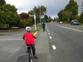
| + | Image:2014_02_23_-43_172_Half_Way_There.JPG | Halfway there | ||
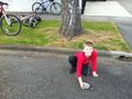
| + | Image:2014_02_23_-43_172_The_Location.JPG | Today's location | ||
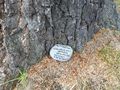
| + | Image:2014_02_23_-43_172_The_Markers_Final_Resting_Spot.JPG | Final resting spot - taking shelter under the tree | ||
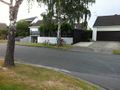
| + | Image:2014_02_23_-43_172_Wide_Angle.JPG| The suburban landscape | ||
| + | </gallery> | ||
| + | |||
| + | == Achievements == | ||
| + | |||
Revision as of 05:21, 23 February 2014

| Sun 23 Feb 2014 in -43,172: -43.5180912, 172.5579196 geohashing.info google osm bing/os kml crox |
Location
Avonhead, Christchurch, Canterbury, New Zealand
Participants
The Quaternary (talk) family geohashers
Plans
Excitement - not only an accessible cache in our dear city, but less than 3km away. Should we walk, bike or bus?
Expedition
We decided to bike. As we left the black clouds looked ominous. And when we arrived, the first spots of rain arrived. (And by the time we had biked home, we were quite wet.)
The spot was on the road (see picture) so we ended up putting the marker under a tree on the verge.
Good to be back home now out of that thunder and lightning!
Tracklog

Photos
Halfway there
Today's location
Final resting spot - taking shelter under the tree
The suburban landscape


