Difference between revisions of "2014-03-22 51 5"
From Geohashing
imported>JwB m |
imported>JwB m |
||
| Line 30: | Line 30: | ||
Image: 2014-03-22 51 5clay.jpg | plouged clay | Image: 2014-03-22 51 5clay.jpg | plouged clay | ||
</gallery> | </gallery> | ||
| + | |||
| + | ==Achievements== | ||
| + | {{Minesweeper geohash | graticule = Utrecht, Netherlands | ranknumber = 2 | s = true | w = true | name = JwB }} | ||
[[Category:Expeditions]] | [[Category:Expeditions]] | ||
[[Category:Expeditions with photos]] | [[Category:Expeditions with photos]] | ||
[[Category:Coordinates reached]] | [[Category:Coordinates reached]] | ||
Revision as of 14:00, 24 March 2014

| Sat 22 Mar 2014 in 51,5: 51.7440204, 5.2771792 geohashing.info google osm bing/os kml crox |
Location
between summer and winter dyke bouding river Maas; Hedel
Participants
Plans
deviate a bit from where I ought to go
Expedition
found the filed swiftly. Fortunately, there was a path (well visible on google earth) that led up to very near the hashpoint (only 10 m to go through the clay). technically, the gate midway the path was closed, but getting over it was no big deal. The field was freshly ploughed, and therefore no damage was done to any crop. The fields before the gate were fresly sowed, and one should not thread there, but this did no harm. makes me realize that likely many hashes will not be reachable during crop-season.
Photos
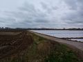
it is behind the sowed part

todays grin
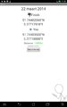
coordinates: reached
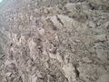
plouged clay


Achievements
JwB achieved level 2 of the Minesweeper Geohash achievement
|