Difference between revisions of "2014-09-21 -43 172"
imported>Quaternary (Created page with "[[Image:{{{image|2014_09_21_-43_172_08.JPG}}}|thumb|left]] <!-- And DON'T FORGET to add your expedition and the best photo you took to the gallery on the Main Page! We'd lov...") |
imported>Quaternary |
||
| Line 1: | Line 1: | ||
| − | [[Image:{{{image|2014_09_21_-43_172_08. | + | [[Image:{{{image|2014_09_21_-43_172_08.jpg}}}|thumb|left]] |
<!-- | <!-- | ||
| Line 40: | Line 40: | ||
<gallery> | <gallery> | ||
| − | Image:2014_09_21_-43_172_Geolocation1. | + | Image:2014_09_21_-43_172_Geolocation1.png | |
| − | Image:2014_09_21_-43_172_Geolocation2. | + | Image:2014_09_21_-43_172_Geolocation2.png | |
</gallery> | </gallery> | ||
| Line 49: | Line 49: | ||
<gallery caption="Photo Gallery" widths="320px" heights="213px" perrow="3"> | <gallery caption="Photo Gallery" widths="320px" heights="213px" perrow="3"> | ||
| − | Image:2014_09_21_-43_172_01. | + | Image:2014_09_21_-43_172_01.jpg | At the car park we happened upon a map which confirmed the geohash was on public land - excellent. |
Image:2014_09_21_-43_172_02.JPG | The Rob Hall Memorial, looking towards the city. | Image:2014_09_21_-43_172_02.JPG | The Rob Hall Memorial, looking towards the city. | ||
| − | Image:2014_09_21_-43_172_03. | + | Image:2014_09_21_-43_172_03.jpg | The Rob Hall Memorial |
| − | Image:2014_09_21_-43_172_04. | + | Image:2014_09_21_-43_172_04.jpg | Plaque |
Image:2014_09_21_-43_172_05.JPG | Zeroing in on the spot | Image:2014_09_21_-43_172_05.JPG | Zeroing in on the spot | ||
Image:2014_09_21_-43_172_06.JPG | Annotating the geohash marker | Image:2014_09_21_-43_172_06.JPG | Annotating the geohash marker | ||
| − | Image:2014_09_21_-43_172_07. | + | Image:2014_09_21_-43_172_07.jpg | The geohash |
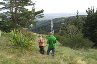
| − | Image:2014_09_21_-43_172_08. | + | Image:2014_09_21_-43_172_08.jpg | View of the flax habouring the geohash marker |
| − | Image:2014_09_21_-43_172_09. | + | Image:2014_09_21_-43_172_09.jpg | Back at the carpark, we are hemmed in by vans and bikes |
</gallery> | </gallery> | ||
Revision as of 08:00, 5 October 2014

| Sun 21 Sep 2014 in -43,172: -43.5961697, 172.6433531 geohashing.info google osm bing/os kml crox |
Location
Port Hills, Christchurch, New Zealand
Participants
The Quaternary (talk) family geohashers
Plans
Today's geohash is in the Port Hills that overlook Christchurch, which is public reserve - this should be simple!
Expedition
From Google Maps it looked like the geohash was near some sort of walking track - and it turned out this was the case - above Victoria Park.
There was a mountain bike track through, and it looked like today was race day!
As we walked towards the geohash, we happened upon a memorial to mountaineer Rob Hall, who died on Mt Everest in 1996. The memorial included a circle of Nepalese prayer flags. So this was a real treat to find this.
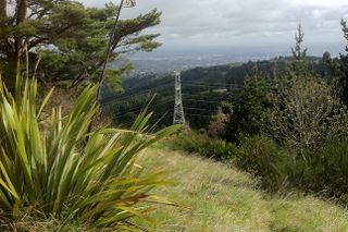
Continuing another few hundred metres and we zeroed in on the geohash, which I reckoned was at the base of a flax, with a beautiful lookout over Christchurch city.
Tracklog


Photos
- Photo Gallery
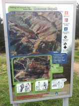
At the car park we happened upon a map which confirmed the geohash was on public land - excellent.
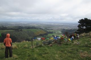
The Rob Hall Memorial, looking towards the city.
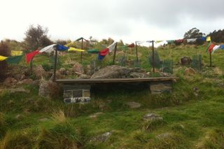
The Rob Hall Memorial
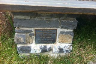
Plaque
Zeroing in on the spot
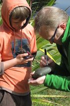
Annotating the geohash marker
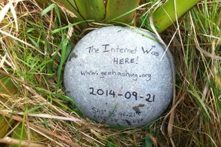
The geohash
View of the flax habouring the geohash marker
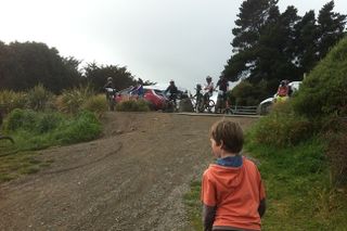
Back at the carpark, we are hemmed in by vans and bikes


