Difference between revisions of "2014-11-29 47 11"
imported>TheOneRing (Created page with "{{meetup graticule | lat=47 | lon=11 | date=2014-11-29 }} == Location == The geohash is in a forest near the Erdfunkstelle Raisting. == Who Went == User:TheOneRing|TheOneR...") |
imported>TheOneRing |
||
| Line 6: | Line 6: | ||
== Location == | == Location == | ||
| − | The geohash is in a forest near the Erdfunkstelle Raisting. | + | The geohash is in a forest near the [http://de.wikipedia.org/wiki/Erdfunkstelle_Raisting Erdfunkstelle Raisting] (sorry, only in German). |
== Who Went == | == Who Went == | ||
[[User:TheOneRing|TheOneRing]] - by foot. | [[User:TheOneRing|TheOneRing]] - by foot. | ||
| − | == The | + | == The Expedition == |
| − | I | + | I was very indecisive whether to go or not, but in the end I decided in favour for this attempt. Mostly because it was so close to my home, just 8.4km as the crow flies. |
| + | |||
| + | I wanted to walk, because it was a little bit too cold to ride my bike. Estimating two hours of walk, I started half past two, to reach the meetup in time. Earlier this year I was on a bike tour and my planned path was along the same road as on that tour. So, I already knew about direction and distance. | ||
| + | |||
| + | After passing Raisting, the only town between home and the geohash, I arrived at the Erdfunkstelle Raisting. It's an array of radar dishes, used for sending and receiving signals from and to satellites orbiting the Earth. From there it was just 3km to the geohash. | ||
| + | |||
| + | I arrived around half past four, after a walk of about 9.4km. The quality of the path decreased with each step: from a street like farm road, over a forest track and a less used forest track onto a deer pass. I saw traces, which I think were boar traces. Because of the trees, the signal was poor and the scale jumped back and forth. I made some photographs, when the distance was shown to be less than 10m to claim a successful arrival. | ||
| + | |||
| + | I went back to the farm track and waited for others to come, but no one else showed up. A little bit before four o'clock I left the spot as I wanted to reach a train in Raisting. But I didn't see anyone approaching anyway. | ||
| + | |||
| + | This was my tenth Saturday meetup, only 90 to go for the complete [[xkcd centurion achievement|xkcd Centurion Achievement]]. | ||
| + | |||
| + | == Photos == | ||
| + | <gallery perrow="5"> | ||
| + | Image:20141129_47_11Artwork.jpg|Some artwork in a tree | ||
| + | Image:20141129_47_11Bridge.jpg|A small bridge, I guess bikers ignore it | ||
| + | Image:20141129_47_11Erdfunkstelle2.jpg|The radar dishes | ||
| + | Image:20141129_47_11Erdfunkstelle4.jpg|..., different angle and while twilight | ||
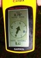
| + | Image:20141129_47_11GPS.jpg|Coordinates reached | ||
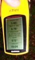
| + | Image:20141129_47_11Info.jpg|Some more information (sorry, blurred) | ||
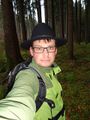
| + | Image:20141129_47_11Me.jpg|The hasher | ||
| + | </gallery> | ||
| + | |||
| + | == Achievements == | ||
| + | {{land geohash | latitude = 47 | longitude = 11 | date = 2014-11-29 | name = TheOneRing}} | ||
| + | {{Walk geohash | latitude = 47 | longitude = 11 | date = 2014-11-29 | name = TheOneRing }} | ||
| + | {{xkcd centurion | count = 10 | name = TheOneRing}} | ||
| + | |||
| + | [[Category:Expeditions]] | ||
| + | [[Category:Expeditions with photos]] | ||
| + | [[Category:Coordinates reached]] | ||
Revision as of 20:35, 29 November 2014
| Sat 29 Nov 2014 in 47,11: 47.8721692, 11.0986994 geohashing.info google osm bing/os kml crox |
Location
The geohash is in a forest near the Erdfunkstelle Raisting (sorry, only in German).
Who Went
TheOneRing - by foot.
The Expedition
I was very indecisive whether to go or not, but in the end I decided in favour for this attempt. Mostly because it was so close to my home, just 8.4km as the crow flies.
I wanted to walk, because it was a little bit too cold to ride my bike. Estimating two hours of walk, I started half past two, to reach the meetup in time. Earlier this year I was on a bike tour and my planned path was along the same road as on that tour. So, I already knew about direction and distance.
After passing Raisting, the only town between home and the geohash, I arrived at the Erdfunkstelle Raisting. It's an array of radar dishes, used for sending and receiving signals from and to satellites orbiting the Earth. From there it was just 3km to the geohash.
I arrived around half past four, after a walk of about 9.4km. The quality of the path decreased with each step: from a street like farm road, over a forest track and a less used forest track onto a deer pass. I saw traces, which I think were boar traces. Because of the trees, the signal was poor and the scale jumped back and forth. I made some photographs, when the distance was shown to be less than 10m to claim a successful arrival.
I went back to the farm track and waited for others to come, but no one else showed up. A little bit before four o'clock I left the spot as I wanted to reach a train in Raisting. But I didn't see anyone approaching anyway.
This was my tenth Saturday meetup, only 90 to go for the complete xkcd Centurion Achievement.
Photos
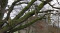
Some artwork in a tree
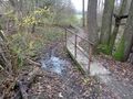
A small bridge, I guess bikers ignore it
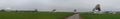
The radar dishes
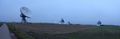
..., different angle and while twilight
Coordinates reached
Some more information (sorry, blurred)
The hasher


Achievements
TheOneRing earned the Land geohash achievement
|
TheOneRing earned the Walk geohash Achievement
|
TheOneRing earned the xkcd Decurion achievement
|