Difference between revisions of "2015-01-19 50 -1"
From Geohashing
imported>Sourcerer m ([live] Fail. No public access.) |
imported>Sourcerer m (→New expedition added) |
||
| Line 1: | Line 1: | ||
| − | |||
| − | |||
| − | |||
| − | |||
| − | |||
| − | |||
| − | |||
| − | |||
| − | |||
| − | |||
{{meetup graticule | {{meetup graticule | ||
| lat=50 | | lat=50 | ||
| Line 15: | Line 5: | ||
}} | }} | ||
| − | |||
__NOTOC__ | __NOTOC__ | ||
| + | |||
== Location == | == Location == | ||
| − | + | ||
| + | Behind live-stock grade hedges, fences and gates, south of East Meon, Hampshire, UK. | ||
== Participants == | == Participants == | ||
| − | + | ||
| − | + | [[User:Sourcerer|Sourcerer]] | |
== Plans == | == Plans == | ||
| Line 29: | Line 20: | ||
== Expedition == | == Expedition == | ||
| − | |||
| + | *Fail. No public access. -- [[User:Sourcerer|Sourcerer]] ([[User talk:Sourcerer|talk]]) [http://www.openstreetmap.org/?lat=50.97483516&lon=-1.03091240&zoom=16&layers=B000FTF @50.9748,-1.0309] 09:37, 19 January 2015 (GMT) | ||
| + | |||
| + | On Monday January 19th Sourcerer set out at 3am, drove 546 miles and attempted seven hashpoints in about 16 hours. Six were reached. This was the failure. | ||
| − | + | The South Downs chalky terrain was looking beautiful in the early morning sunlight. Sadly the hashpoint was 400 metres away behind well maintained fences, hedges and gates. I'm happy to do a mini-trespass if it's possible to lurk without doing any damage. This would have been a break-in. | |
| − | |||
| − | |||
== Photos == | == Photos == | ||
| − | + | ||
| − | |||
| − | |||
<gallery perrow="5"> | <gallery perrow="5"> | ||
| + | Image:2015-01-19-Sourcerer.jpg | Overview | ||
| + | Image:2015-01-19_50_-1_Sourcerer_1.jpg | 400 Metres Away | ||
</gallery> | </gallery> | ||
| − | |||
| − | |||
| − | |||
| + | == Consolation Prize == | ||
| + | {{No trespassing | ||
| + | | latitude = 50 | ||
| + | | longitude = -1 | ||
| + | | date = 2015-01-19 | ||
| + | | name = Sourcerer | ||
| + | | distance = 400m | ||
| + | }} | ||
| − | + | == Other geohashing expeditions on the same day == | |
| − | |||
| − | |||
| − | |||
| − | |||
| − | + | {{expedition summaries|2015-01-19}} | |
| − | |||
| − | |||
| − | |||
| − | |||
[[Category:Expeditions]] | [[Category:Expeditions]] | ||
| − | |||
[[Category:Expeditions with photos]] | [[Category:Expeditions with photos]] | ||
| − | |||
| − | |||
| − | |||
| − | |||
| − | |||
| − | |||
| − | |||
| − | |||
| − | |||
[[Category:Coordinates not reached]] | [[Category:Coordinates not reached]] | ||
| − | |||
| − | |||
| − | |||
| − | |||
| − | |||
| − | |||
| − | |||
| − | |||
| − | |||
| − | |||
| − | |||
| − | |||
| − | |||
| − | |||
Revision as of 06:30, 20 January 2015
| Mon 19 Jan 2015 in 50,-1: 50.9772974, -1.0252522 geohashing.info google osm bing/os kml crox |
Location
Behind live-stock grade hedges, fences and gates, south of East Meon, Hampshire, UK.
Participants
Plans
If successful, this will be hashpoint 3 of 7 today. --Sourcerer (talk) 10:24, 18 January 2015 (EST)
Expedition
- Fail. No public access. -- Sourcerer (talk) @50.9748,-1.0309 09:37, 19 January 2015 (GMT)
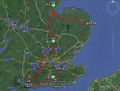
On Monday January 19th Sourcerer set out at 3am, drove 546 miles and attempted seven hashpoints in about 16 hours. Six were reached. This was the failure.
The South Downs chalky terrain was looking beautiful in the early morning sunlight. Sadly the hashpoint was 400 metres away behind well maintained fences, hedges and gates. I'm happy to do a mini-trespass if it's possible to lurk without doing any damage. This would have been a break-in.
Photos
Overview
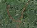
400 Metres Away


Consolation Prize
Sourcerer earned the No trespassing consolation prize
|
Other geohashing expeditions on the same day
Expeditions and Plans
| 2015-01-19 | ||
|---|---|---|
| Atlanta, Georgia | NWoodruff | On the playground of an elementary school in Lawrenceville. |
| Jacksonville, Illinois | Mystrsyko, Dolphintreasure | In a field near Cox Creek, north of Ashland, IL. |
| Newark, New Jersey | OtherJack, Jevanyn | Back of someone's house in Emerson. |
| Brighton, United Kingdom | Sourcerer | 2) On deep frozen common heath-land north of North Chailey, East Sussex, UK... |
| Southampton, United Kingdom | Sourcerer | 3) Behind live-stock grade hedges, fences and gates, south of East Meon, Ha... |
| Eastbourne, United Kingdom | Sourcerer | 1) South east of a sewage works in a hard-frozen field, Newick, East Sussex... |
| Erfurt, Germany | FeepingCreature | Hash is in a parking lot in the town center of Erfurt. Extremely reachable.... |
| London West, United Kingdom | Sourcerer | 4) In a field of winter wheat, east of the A10 trunk road, between Buckland... |
| London East, United Kingdom | Sourcerer | 5) In a field of winter wheat, west of Anstey and a quarry, Hertfordshire, ... |
| Northampton, United Kingdom | Sourcerer | 6) A double pub geohash beside the River Witham in the middle of Boston, Li... |
| Cambridge, United Kingdom | Sourcerer | 7) In a muddy field, east of Boston, Lincolnshire, UK. |