Difference between revisions of "2015-02-26 52 1"
From Geohashing
imported>Sourcerer m ([live picture] Proof. [http://www.openstreetmap.org/?lat=52.73131728&lon=1.47127748&zoom=16&layers=B000FTF @52.7313,1.4713]) |
imported>Sourcerer m (→New Expedition) |
||
| Line 15: | Line 15: | ||
== Expedition == | == Expedition == | ||
| − | + | This was the first of two points spanning midnight: [[2015-02-26 52 1]] :: [[2015-02-27 52 0]] | |
| + | *Arrived. -- [[User:Sourcerer|Sourcerer]] ([[User talk:Sourcerer|talk]]) [http://www.openstreetmap.org/?lat=52.73131192&lon=1.47128284&zoom=16&layers=B000FTF @52.7313,1.4713] 21:53, 26 February 2015 (GMT) | ||
| + | |||
| + | This went to plan. The special feature: This was Sourcerer's 100th coordinates reached in 52, 1. | ||
| − | |||
== Photos == | == Photos == | ||
<gallery perrow="5"> | <gallery perrow="5"> | ||
| − | |||
Image:2015-02-26_52_1_Sourcerer_1424987551344.jpg | Proof. [http://www.openstreetmap.org/?lat=52.73131728&lon=1.47127748&zoom=16&layers=B000FTF @52.7313,1.4713] | Image:2015-02-26_52_1_Sourcerer_1424987551344.jpg | Proof. [http://www.openstreetmap.org/?lat=52.73131728&lon=1.47127748&zoom=16&layers=B000FTF @52.7313,1.4713] | ||
| + | Image:2015-02-26_52_1_Sourcerer_2.jpg | Track Log | ||
| + | Image:2015-02-26_52_1_Sourcerer_3.jpg | Selfie with party blower/tickler | ||
</gallery> | </gallery> | ||
== Achievements == | == Achievements == | ||
{{#vardefine:ribbonwidth|800px}} | {{#vardefine:ribbonwidth|800px}} | ||
| − | |||
{{consecutive geohash 2 | {{consecutive geohash 2 | ||
| count = 12 | | count = 12 | ||
| Line 36: | Line 38: | ||
| name = Sourcerer | | name = Sourcerer | ||
}} | }} | ||
| − | -- | + | {{gratuitous ribbon |
| + | | latitude = 52 | ||
| + | | longitude = 1 | ||
| + | | date = 2015-02-26 | ||
| + | | achievement = HectoHash Achievement | ||
| + | | description = reaching 100 hashpoints in the Norwich 52,1 graticule | ||
| + | | name = Sourcerer | ||
| + | | icon = 2015-02-26_52_1_Sourcerer_3.jpg | ||
| + | }} | ||
== Other geohashing expeditions on the same day == | == Other geohashing expeditions on the same day == | ||
{{expedition summaries|2015-02-26}} | {{expedition summaries|2015-02-26}} | ||
| − | |||
| − | |||
[[Category:Expeditions]] | [[Category:Expeditions]] | ||
[[Category:Expeditions with photos]] | [[Category:Expeditions with photos]] | ||
[[Category:Coordinates reached]] | [[Category:Coordinates reached]] | ||
| − | |||
Revision as of 02:00, 27 February 2015
| Thu 26 Feb 2015 in 52,1: 52.7313236, 1.4712510 geohashing.info google osm bing/os kml crox |
Location
In a field close to a public path south of Neatishead, Norfolk, UK.
Participants
Expedition
This was the first of two points spanning midnight: 2015-02-26 52 1 :: 2015-02-27 52 0
- Arrived. -- Sourcerer (talk) @52.7313,1.4713 21:53, 26 February 2015 (GMT)
This went to plan. The special feature: This was Sourcerer's 100th coordinates reached in 52, 1.
Photos
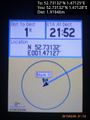
Proof. @52.7313,1.4713
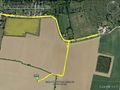
Track Log
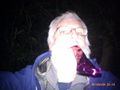
Selfie with party blower/tickler


Achievements
Sourcerer earned the Consecutive geohash achievement
|
Sourcerer earned the HectoHash Achievement
|
Other geohashing expeditions on the same day
Expeditions and Plans
| 2015-02-26 | ||
|---|---|---|
| Norwich, United Kingdom | Sourcerer | In a field close to a public path south of Neatishead, Norfolk, UK. |
| Enschede, Netherlands | Tchakkazulu | located on Crerarstraat in Hoogeveen. |