Difference between revisions of "2013-03-11 43 -77"
From Geohashing
imported>HicSuntLaganum (Created page with "{{meetup graticule | lat=43 | lon=-77 | date=2013-03-11 | graticule_name=Rochester | graticule_link=Rochester, New York }} == Location == Leeward Lane Cul de Sac == Particip...") |
imported>FippeBot m (Location) |
||
| Line 29: | Line 29: | ||
[[Category:Expeditions with photos]] | [[Category:Expeditions with photos]] | ||
[[Category:Coordinates reached]] | [[Category:Coordinates reached]] | ||
| + | {{location|US|NY|MR}} | ||
Latest revision as of 01:24, 14 August 2019
| Mon 11 Mar 2013 in Rochester: 43.1053049, -77.5454309 geohashing.info google osm bing/os kml crox |
Location
Leeward Lane Cul de Sac
Participants
Expedition
- Hic Sunt Laganum
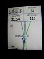
- Thankfully this point was within an achievable distance considering that scheduling meant that we would not be able to head to the point sooner. Nothing of note to speak of about this point, it was dark and there was no moon so little could be seen around the area. Leaving the car was not even necessary to achieve this one.
Photos
Achievements
HicSuntLaganum earned the Land geohash achievement
|
