Difference between revisions of "2014-06-14 43 -77"
From Geohashing
imported>HicSuntLaganum (Created page with "{{meetup graticule | lat=43 | lon=-77 | date=2014-06-14 | graticule_name=Rochester | graticule_link=Rochester, New York }} == Location == Buckwheat Drive == Participants == ...") |
imported>FippeBot m (Location) |
||
| Line 29: | Line 29: | ||
[[Category:Expeditions with photos]] | [[Category:Expeditions with photos]] | ||
[[Category:Coordinates reached]] | [[Category:Coordinates reached]] | ||
| + | {{location|US|NY|MR}} | ||
Latest revision as of 06:52, 14 August 2019
| Sat 14 Jun 2014 in Rochester: 43.1130550, -77.4350396 geohashing.info google osm bing/os kml crox |
Location
Buckwheat Drive
Participants
Expedition
- Hic Sunt Laganum
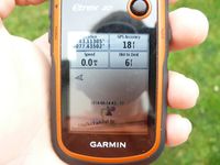
- The housing track the point is in has streets named for crops like wheat or farms. There are no fields nearby, just houses. To get this point, we just had to ask if we could take a picture of our GSP, the sidewalk to the front door was close enough we didn't need to step on the grass.
Photos
Achievements
HicSuntLaganum earned the Land geohash achievement
|
