Difference between revisions of "2015-06-06 66 24"
From Geohashing
imported>Isopekka (Created page with "thumb|left {{meetup graticule | lat=66 | lon=24 | date=2015-06-06 }} == Location == In Ylitornio, in Raja-aapa. == Participant...") |
imported>FippeBot m (Location) |
||
| Line 75: | Line 75: | ||
[[Category:Expeditions with photos]] | [[Category:Expeditions with photos]] | ||
[[Category:Coordinates reached]] | [[Category:Coordinates reached]] | ||
| + | {{location|FI|10}} | ||
Latest revision as of 03:56, 15 August 2019

| Sat 6 Jun 2015 in 66,24: 66.3981129, 24.8971436 geohashing.info google osm bing/os kml crox |
Contents
Location
In Ylitornio, in Raja-aapa.
Participants
- isopekka and wife
Expedition
- Driving total 100 km
- Walking total 1.2 km
- Expedition took 3 h
- Physical effort (1-5): 2
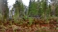
Expedition started about at 2.30 p.m. The hashpoint situated in the forest.
Photos
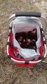
On the way to the Hash we picked up some Gyromitra esculenta mushrooms
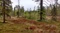
600 m to the Hash.
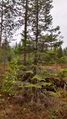
The Hash.
The Proof.
View from the Hash.


Achievements
isopekka earned the Land geohash achievement
|
Geohashing Expeditions and Plans on This Day
Expeditions and Plans
| 2015-06-06 | ||
|---|---|---|
| Portland, Oregon | Shmur | South bank of the Tualatin river, in what appears to be farmland inside or ... |
| Tervola, Finland | isopekka | In Ylitornio, in Raja-aapa. |