Difference between revisions of "2015-06-15 52 1"
From Geohashing
imported>Sourcerer m (→New Expedition) |
imported>Sourcerer m (→Photo) |
||
| Line 27: | Line 27: | ||
<gallery perrow="5"> | <gallery perrow="5"> | ||
Image:2015-06-15_52_1_Sourcerer_1434404530333.jpg | Proof. [http://www.openstreetmap.org/?lat=52.00680435&lon=1.13461733&zoom=16&layers=B000FTF @52.0068,1.1346] | Image:2015-06-15_52_1_Sourcerer_1434404530333.jpg | Proof. [http://www.openstreetmap.org/?lat=52.00680435&lon=1.13461733&zoom=16&layers=B000FTF @52.0068,1.1346] | ||
| + | Image:2015-06-15 52 1 Sourcerer.jpg | Google Earth Track Log | ||
</gallery> | </gallery> | ||
Revision as of 01:12, 16 June 2015
| Mon 15 Jun 2015 in 52,1: 52.0067161, 1.1345829 geohashing.info google osm bing/os kml crox |
Location
In woodland, Holbrook Park, Suffolk, UK.
Participants
Plans
Expedition one of two spanning midnight - 2015-06-15 52 1 - 2015-06-16 52 0 - ETA 22:40
Expedition
- Arrived. -- Sourcerer (talk) @52.0068,1.1346 22:43, 15 June 2015 (GMT+01:00)
I followed a field perimeter tractor track. This lead to the woodland. An obvious, wide trail lead in the right direction. Finally there was a 20 metre scramble over rotting branches to reach the hashpoint. I had expected gates and fences but there were none.
Photos
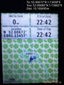
Proof. @52.0068,1.1346
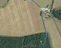
Google Earth Track Log


Achievements
Sourcerer earned the Consecutive geohash achievement
|
Other geohashing expeditions on the same day
Expeditions and Plans
| 2015-06-15 | ||
|---|---|---|
| Shrewsbury, United Kingdom | Someone went | A field just north of Tewkesbury. I've never been to Tewkesbury but I've se... |
| Norwich, United Kingdom | Sourcerer | In woodland, Holbrook Park, Suffolk, UK. |
| Braunschweig, Germany | GeorgDerReisende | The hash lay behind a fence at some ponds in Bockenem. |
| Peltovuoma, Finland | isopekka | In Pallasjärvi, near the road. |