Difference between revisions of "2015-07-21 47 16"
From Geohashing
imported>B2c m |
imported>B2c m |
||
| Line 7: | Line 7: | ||
== Location == | == Location == | ||
| − | + | Next to a small access road at the Austrian-Hungarian border near Klingenbach. | |
== Participants == | == Participants == | ||
| Line 16: | Line 16: | ||
== Plans == | == Plans == | ||
| + | We were headed for the [[2015-07-21 global]] hash and this hashpoint was more or less a collateral. ;) | ||
| + | |||
== Expedition == | == Expedition == | ||
| + | This one went pretty well. We diverged from the federal road, drove up a hill, jumped out of the car into the glaring heat to collect the hash and were on our way again. | ||
| − | *Yay, there in the heat!! -- [[User:Micsnare|Micsnare]] ([[User talk:Micsnare|talk]]) [http://www.openstreetmap.org/?lat=47.76054704&lon=16.54819815&zoom=16&layers=B000FTF @47.7605,16.5482] 17:14, 21 July 2015 (GMT+02:00) | + | Original posts from Micsnare and Patrizius: |
| + | * Yay, there in the heat!! -- [[User:Micsnare|Micsnare]] ([[User talk:Micsnare|talk]]) [http://www.openstreetmap.org/?lat=47.76054704&lon=16.54819815&zoom=16&layers=B000FTF @47.7605,16.5482] 17:14, 21 July 2015 (GMT+02:00) | ||
| − | *:) -- [[User:Patrizius|Patrizius]] ([[User talk:Patrizius|talk]]) [http://www.openstreetmap.org/?lat=47.76055312&lon=16.54818398&zoom=16&layers=B000FTF @47.7606,16.5482] 17:14, 21 July 2015 (GMT+02:00) | + | * :) -- [[User:Patrizius|Patrizius]] ([[User talk:Patrizius|talk]]) [http://www.openstreetmap.org/?lat=47.76055312&lon=16.54818398&zoom=16&layers=B000FTF @47.7606,16.5482] 17:14, 21 July 2015 (GMT+02:00) |
== Tracklog == | == Tracklog == | ||
| − | n/a | + | n/a - check the globalhash report. |
| Line 32: | Line 36: | ||
<gallery caption="Photo Gallery" widths="320px" heights="213px" perrow="3"> | <gallery caption="Photo Gallery" widths="320px" heights="213px" perrow="3"> | ||
Image:2015-07-21_47_16_patrizius_1437491748833.jpg | Stupid Grin (tm) [http://www.openstreetmap.org/?lat=47.76044342&lon=16.54810016&zoom=16&layers=B000FTF @47.7604,16.5481] | Image:2015-07-21_47_16_patrizius_1437491748833.jpg | Stupid Grin (tm) [http://www.openstreetmap.org/?lat=47.76044342&lon=16.54810016&zoom=16&layers=B000FTF @47.7604,16.5481] | ||
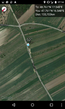
| + | Image:Screenshot_2015-07-21-17-13-43.png | Proof | ||
| + | Image:Screenshot_2015-07-21-17-14-45.png | More proof. | ||
</gallery> | </gallery> | ||
Revision as of 09:32, 22 July 2015
| Tue 21 Jul 2015 in 47,16: 47.7605390, 16.5481940 geohashing.info google osm bing/os kml crox |
Location
Next to a small access road at the Austrian-Hungarian border near Klingenbach.
Participants
Plans
We were headed for the 2015-07-21 global hash and this hashpoint was more or less a collateral. ;)
Expedition
This one went pretty well. We diverged from the federal road, drove up a hill, jumped out of the car into the glaring heat to collect the hash and were on our way again.
Original posts from Micsnare and Patrizius:
- Yay, there in the heat!! -- Micsnare (talk) @47.7605,16.5482 17:14, 21 July 2015 (GMT+02:00)
- :) -- Patrizius (talk) @47.7606,16.5482 17:14, 21 July 2015 (GMT+02:00)
Tracklog
n/a - check the globalhash report.
Photos
- Photo Gallery
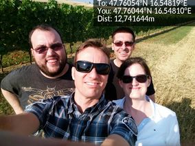
Stupid Grin (tm) @47.7604,16.5481

Proof
More proof.


