Difference between revisions of "2015-08-02 48 13"
From Geohashing
imported>B2c m |
imported>B2c m (→Achievements) |
||
| Line 49: | Line 49: | ||
== Achievements == | == Achievements == | ||
| − | |||
| − | |||
| − | |||
| − | |||
| − | |||
| − | |||
| − | |||
| − | |||
| − | |||
| − | |||
| − | |||
| − | |||
| − | |||
| − | |||
| − | |||
{{#vardefine:ribbonwidth|800px}} | {{#vardefine:ribbonwidth|800px}} | ||
<!-- Add any achievement ribbons you earned below, or remove this section --> | <!-- Add any achievement ribbons you earned below, or remove this section --> | ||
Revision as of 11:26, 4 August 2015
| Sun 2 Aug 2015 in 48,13: 48.0012012, 13.7057050 geohashing.info google osm bing/os kml crox |
Location
All stops in consecutive order:
|
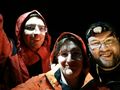
Participants
Plans / Expedition
This is part of an elevenfold multihash. For the complete report of the multihash please head over here.
- Two down! -- B2c (talk) @48.0033,13.7075 02:41, 2 August 2015 (GMT+02:00)
Tracklog
Photos
Drowned Rat meet Velociraptor....


Achievements