Difference between revisions of "2015-08-02 43 -85"
imported>Mcbaneg (Created page with "<!-- If you did not specify these parameters in the template, please substitute appropriate values for IMAGE, LAT, LON, and DATE (YYYY-MM-DD format) {{{image|dummy.jpg}}}|...") |
imported>Mcbaneg |
||
| Line 52: | Line 52: | ||
<!-- Potential categories. Please include all the ones appropriate to your expedition --> | <!-- Potential categories. Please include all the ones appropriate to your expedition --> | ||
| − | |||
[[Category:Expeditions]] | [[Category:Expeditions]] | ||
[[Category:Expeditions with photos]] | [[Category:Expeditions with photos]] | ||
[[Category:Coordinates reached]] | [[Category:Coordinates reached]] | ||
Revision as of 21:11, 2 August 2015
| Sun 2 Aug 2015 in 43,-85: 43.0012012, -85.7057050 geohashing.info google osm bing/os kml crox |
Location
loading area for greenhouses behind a factory, Walker, MI, USA
Participants
Expedition
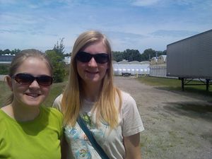
Katja drove up, Rebekah drove home. We parked in the main lot for the ArtiFlex tooling factory (empty on Sunday afternoon) and walked around back. The hashpoint was just off the access road for the greenhouses that are lined up behind the factory. It was hot and sunny and not very interesting, and felt a little creepy and desolate on Sunday, so we took the requisite photos and headed out.
Our route home passed just a few meters from the first Michigan hashpoint that Rebekah and I reached at 2013-08-17_42_-85. I asked her to turn down Jenette St. so we could revisit it for old times' sake.
Photos
View east along Richmond Street near former hashpoint, for comparison with earlier photo from 2013-08-17_42_-85. This was taken on the fly as we turned south into Jenette St from the west; the earlier view of the same street sign was taken from the hashpoint, just southwest of the sign.


