Difference between revisions of "2015-08-30 52 1"
From Geohashing
imported>Sourcerer m ([live picture] Closer. Still a fail. [http://www.openstreetmap.org/?lat=52.58340955&lon=1.57274008&zoom=16&layers=B000FTF @52.5834,1.5727]) |
imported>Sourcerer m (→New Expedition) |
||
| Line 20: | Line 20: | ||
== Expedition == | == Expedition == | ||
| + | *Fail. Sweet corn. -- [[User:Sourcerer|Sourcerer]] ([[User talk:Sourcerer|talk]]) [http://www.openstreetmap.org/?lat=52.58279800&lon=1.56656563&zoom=16&layers=B000FTF @52.5828,1.5666] 22:58, 30 August 2015 (GMT+01:00) | ||
| + | This was a bit of a no-hoper. The sweet corn was ten feet tall and any tractor tracks were totally overgrown. I could have broken through with extensive crop damage and perhaps self damage too. I gave up 125 metres from the hashpoint. At least we don't have corn snakes! | ||
| − | |||
| − | |||
== Photos == | == Photos == | ||
<gallery perrow="5"> | <gallery perrow="5"> | ||
| − | |||
Image:2015-08-30_52_1_Sourcerer_1440971821671.jpg | Proof of fail. [http://www.openstreetmap.org/?lat=52.58279800&lon=1.56657100&zoom=16&layers=B000FTF @52.5828,1.5666] | Image:2015-08-30_52_1_Sourcerer_1440971821671.jpg | Proof of fail. [http://www.openstreetmap.org/?lat=52.58279800&lon=1.56657100&zoom=16&layers=B000FTF @52.5828,1.5666] | ||
| − | |||
Image:2015-08-30_52_1_Sourcerer_1440972916800.jpg | Closer. Still a fail. [http://www.openstreetmap.org/?lat=52.58340955&lon=1.57274008&zoom=16&layers=B000FTF @52.5834,1.5727] | Image:2015-08-30_52_1_Sourcerer_1440972916800.jpg | Closer. Still a fail. [http://www.openstreetmap.org/?lat=52.58340955&lon=1.57274008&zoom=16&layers=B000FTF @52.5834,1.5727] | ||
| + | Image:2015-08-31 52 1 Sourcerer.jpg | Track in Google Earth | ||
</gallery> | </gallery> | ||
| Line 43: | Line 42: | ||
}} | }} | ||
| − | + | ||
| − | |||
[[Category:Expeditions]] | [[Category:Expeditions]] | ||
[[Category:Expeditions with photos]] | [[Category:Expeditions with photos]] | ||
| − | [[Category:Coordinates reached]] | + | [[Category:Coordinates not reached]] |
| − | |||
Revision as of 23:51, 30 August 2015
| Sun 30 Aug 2015 in 52,1: 52.5825550, 1.5715287 geohashing.info google osm bing/os kml crox |
Location
In a field north of Reedham, Norfolk UK.
Participants
Plans
Expedition one of two spanning midnight - 2015-08-30 52 1 - 2015-08-31 52 1 - ETA 23:05.
Expedition
- Fail. Sweet corn. -- Sourcerer (talk) @52.5828,1.5666 22:58, 30 August 2015 (GMT+01:00)
This was a bit of a no-hoper. The sweet corn was ten feet tall and any tractor tracks were totally overgrown. I could have broken through with extensive crop damage and perhaps self damage too. I gave up 125 metres from the hashpoint. At least we don't have corn snakes!
Photos
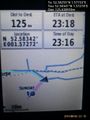
Proof of fail. @52.5828,1.5666
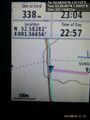
Closer. Still a fail. @52.5834,1.5727
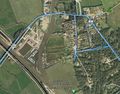
Track in Google Earth


Achievements
Expeditions and Plans
| 2015-08-30 | ||
|---|---|---|
| Boise, Idaho | Eldin, Borneo | Southern corner of the Nampa Civic Center, near the back doors and dumpster... |
| Cambridge, United Kingdom | Tongs, All four of the | In the northeastern corner of the grounds of Oxbrough Hall, Oxborough, Norf... |
| Norwich, United Kingdom | Sourcerer | In a field north of Reedham, Norfolk UK. |
Sourcerer's Expedition Links
2015-08-28 52 1 - 2015-08-30 52 1 - 2015-08-31 52 1 - KML file download of Sourcerer's expeditions for use with Google Earth.