Difference between revisions of "2015-09-13 52 0"
imported>Sourcerer m (→New Expedition) |
imported>Sourcerer m (→Achievements) |
||
| Line 51: | Line 51: | ||
| prev = 2015-09-12 52 0 | | prev = 2015-09-12 52 0 | ||
| curr = 2015-09-13 52 0 | | curr = 2015-09-13 52 0 | ||
| − | | next = 2015-09- | + | | next = 2015-09-16 52 1 |
| date = 2015-09-13 | | date = 2015-09-13 | ||
}} | }} | ||
Revision as of 14:29, 15 September 2015
| Sun 13 Sep 2015 in 52,0: 52.1483814, 0.9624462 geohashing.info google osm bing/os kml crox |
Location
A front drive at Battisford Tye, Suffolk, UK - hindering.bronzer.printout.
Participants
Plans
Expedition two of two spanning midnight - 2015-09-12 52 0 - 2015-09-13 52 0 - ETA 00:00.
Expedition
- Arrived -- Sourcerer (talk) @52.1481,.9629 00:03, 13 September 2015 (GMT+01:00)
According to the Google Earth satellite view, I had reached the point. On the ground, the point appeared to be over the fence. a few metres into the next property. As I was making crunching noises in the gravel at midnight, I didn't try to hash-dance any closer. On a similar expedition, Google showed the hashpoint on the wrong side of the fence so I didn't claim that one. Today Google falls in my favour so I'll claim this one.
Photos
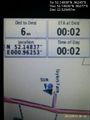
Proof. @52.1484,.9628
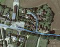
Track in Google Earth


Achievements
Sourcerer earned the OpenStreetMap achievement
|
Sourcerer earned the Midnight Geohash achievement
|
Expeditions and Plans
| 2015-09-13 | ||
|---|---|---|
| Colac, Australia | Benjamin Kaiser | Farm near Inverleigh. |
| Kaiserslautern, Germany | strongblackcoffee | On the edge of Münchweiler am Klingbach |
| Cambridge, United Kingdom | Sourcerer | A front drive at Battisford Tye, Suffolk, UK - hindering.bronzer.printout. |
Sourcerer's Expedition Links
2015-09-12 52 0 - 2015-09-13 52 0 - 2015-09-16 52 1 - KML file download of Sourcerer's expeditions for use with Google Earth.