Difference between revisions of "2015-09-12 51 -1"
imported>SpiritofMaurice (Initial writeup - more to follow) |
imported>SpiritofMaurice |
||
| Line 31: | Line 31: | ||
<gallery perrow="5"> | <gallery perrow="5"> | ||
| − | Image: | + | Image:Screenshot 2015-09-12-18-08-50.jpg | 400m to go and things are looking promising... |
| + | Image:20150912 180651.jpg | The view from this point looks awesome. As far as I can tell the geohash is on the next ridge ahead, happy days! | ||
| + | Image:20150912_181333.jpg | OH GOD THIS IS NOT PASSABLE | ||
| + | Image: 20150912 181817.jpg | Dejected, turned for home, admiring the view and a great walk outside nevertheless. | ||
</gallery> | </gallery> | ||
| Line 37: | Line 40: | ||
{{#vardefine:ribbonwidth|800px}} | {{#vardefine:ribbonwidth|800px}} | ||
| − | {{ | + | {{mnb geohash |
| − | + | | latitude = 51 | |
| − | + | | longitude = -1 | |
| − | + | | date = 2015-09-12 | |
| − | + | | name = SpiritofMaurice | |
| − | + | | image = 20150912_181333.jpg | |
| − | |||
}} | }} | ||
| + | {{No trespassing | ||
| + | | latitude = 51 | ||
| + | | longitude = -1 | ||
| + | | date = 2015-09-12 | ||
| + | | name = SpiritofMaurice | ||
| + | | distance = 180m | ||
| + | }} | ||
[[Category:Expeditions]] | [[Category:Expeditions]] | ||
[[Category:Expeditions with photos]] | [[Category:Expeditions with photos]] | ||
[[Category:Coordinates not reached]] | [[Category:Coordinates not reached]] | ||
[[Category:Not reached - Mother Nature]] | [[Category:Not reached - Mother Nature]] | ||
| + | [[Category:No trespassing consolation prize]] | ||
Revision as of 22:43, 15 September 2015
| Sat 12 Sep 2015 in 51,-1: 51.1193204, -1.7949829 geohashing.info google osm bing/os kml crox |
Location
A field in Wiltshire, just north of Salisbury and the ancient fortification of Old Sarum, just south of the even more ancient monument Stonehenge.
Participants
Plans
I drove up for an airshow nearby where I hoped to see XH558, the world's last flying Vulcan bomber, on her final flight ever down south. Noticing this was just a couple of kilometres away... "how hard could it be?"
Expedition
Followed Google Maps as close as I could to the lat/long point, where I noticed three things as the hashpoint zipped past on my left: a), nowhere to stop the car on a fast road; b), some pretty big hedges
Drove around to a small English country lane, eventually parked up and started walking along a public footpath. Across a pig farm!
Eventually lost track of the path, started following my nose (and GPS app) across two fields... (more to follow)
Photos
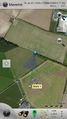
400m to go and things are looking promising...
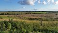
The view from this point looks awesome. As far as I can tell the geohash is on the next ridge ahead, happy days!
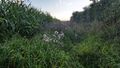
OH GOD THIS IS NOT PASSABLE
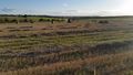
Dejected, turned for home, admiring the view and a great walk outside nevertheless.


Achievements
SpiritofMaurice earned the No trespassing consolation prize
|