Difference between revisions of "2015-10-11 52 1"
From Geohashing
imported>Sourcerer m (→New Expedition) |
imported>Sourcerer m (→Plans) |
||
| Line 16: | Line 16: | ||
== Plans == | == Plans == | ||
| − | Expedition one of two spanning midnight - [[2015-10-11 52 1]] - [[2015-10-12 52 1]] - ETA 22:30. | + | Expedition one of two spanning midnight - [[2015-10-11 52 1]] - [[2015-10-12 52 1]] - ETA 22:30. [http://w3w.co/entrusted.milkman.roving entrusted.milkman.roving] |
== Expedition == | == Expedition == | ||
Revision as of 18:09, 13 October 2015
| Sun 11 Oct 2015 in 52,1: 52.8166395, 1.1478919 geohashing.info google osm bing/os kml crox |
Location
In a field south east of Corpusty, Norfolk, UK.
Participants
Plans
Expedition one of two spanning midnight - 2015-10-11 52 1 - 2015-10-12 52 1 - ETA 22:30. entrusted.milkman.roving
Expedition
- Arrived. -- Sourcerer (talk) @52.8166,1.1479 22:28, 11 October 2015 (GMT+01:00)
There was a neatly mown grassy roadside verge to park on. The public footpath led into a field of sugar beet. The path quickly disappeared so I followed tractor tracks instead. Some of these had filled with water. The track-log shows my approach, anticlockwise round the loops. This was easy enough but a little damp.
Photos
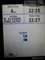
Proof. @52.8166,1.1479
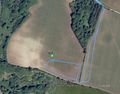
Track in Google Earth


Achievements
Expeditions and Plans
| 2015-10-11 | ||
|---|---|---|
| Innsbruck, Austria | TheOneRing | on a meadow near Weilheim. |
| Norwich, United Kingdom | Sourcerer | In a field south east of Corpusty, Norfolk, UK. |
Sourcerer's Expedition Links
2015-10-09 52 1 - 2015-10-11 52 1 - 2015-10-12 52 1 - KML file download of Sourcerer's expeditions for use with Google Earth.