Difference between revisions of "2015-10-15 52 1"
From Geohashing
imported>Sourcerer m ([live picture] Fail. [http://www.openstreetmap.org/?lat=52.34103441&lon=1.20765388&zoom=16&layers=B000FTF @52.3410,1.2077]) |
imported>Sourcerer m (→New Expedition) |
||
| Line 22: | Line 22: | ||
== Expedition == | == Expedition == | ||
| − | + | The pasture was for horses and very well fenced. | |
== Photos == | == Photos == | ||
| Line 40: | Line 40: | ||
}} | }} | ||
| − | |||
| − | |||
[[Category:Expeditions]] | [[Category:Expeditions]] | ||
[[Category:Expeditions with photos]] | [[Category:Expeditions with photos]] | ||
| − | [[Category:Coordinates reached]] | + | [[Category:Coordinates not reached]] |
| − | |||
Revision as of 01:37, 16 October 2015
| Thu 15 Oct 2015 in 52,1: 52.3408065, 1.2076073 geohashing.info google osm bing/os kml crox |
Location
In a pasture north of Cross Street, Suffolk, UK.
Participants
Plans
Expedition one of six spanning midnight. It's not obvious how to reach this point and the chances of success are lower than usual.
2015-10-15 52 1 - 2015-10-15 52 0 - 2015-10-15 52 -0 - 2015-10-16 52 -0 - 2015-10-16 52 0 - 2015-10-16 52 1 - ETA 21:15.
Expedition
The pasture was for horses and very well fenced.
Photos
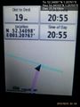
Fail. @52.3410,1.2077

Achievements
Expeditions and Plans
| 2015-10-15 | ||
|---|---|---|
| Northampton, United Kingdom | Sourcerer | 3) On the A14/A141 roundabout, Huntingdon, Cambridgeshire, UK. |
| Cambridge, United Kingdom | Sourcerer | 2) In a field south of Stretham, Cambridgeshire, UK. |
| Norwich, United Kingdom | Sourcerer | 1) In a pasture north of Cross Street, Suffolk, UK. |
Sourcerer's Expedition Links
2015-10-14 52 0 - 2015-10-15 52 1 - 2015-10-15 52 0 - KML file download of Sourcerer's expeditions for use with Google Earth.