Difference between revisions of "2015-11-12 52 0"
From Geohashing
imported>Sourcerer m ([live] Arrived.) |
imported>Sourcerer m ([live picture] Proof. [http://www.openstreetmap.org/?lat=52.66914368&lon=.85652590&zoom=16&layers=B000FTF @52.6691,.8565]) |
||
| Line 26: | Line 26: | ||
== Photos == | == Photos == | ||
<gallery> | <gallery> | ||
| + | |||
| + | Image:2015-11-12_52_0_Sourcerer_1447369666895.jpg | Proof. [http://www.openstreetmap.org/?lat=52.66914368&lon=.85652590&zoom=16&layers=B000FTF @52.6691,.8565] | ||
</gallery> | </gallery> | ||
Revision as of 23:09, 12 November 2015
| Thu 12 Nov 2015 in 52,0: 52.6691404, 0.8565536 geohashing.info google osm bing/os kml crox |
Location
A road hashpoint south of the A47 near Wendling, Norfolk, UK.
Participants
Plans
Expedition one of two spanning midnight - 2015-11-12 52 0 - 2015-11-13 52 1 - ETA 23:15.
Expedition
- Arrived. -- Sourcerer (talk) @52.6691,.8565 23:08, 12 November 2015 (GMT)
Photos
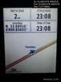
Proof. @52.6691,.8565

Achievements
Expeditions and Plans
| 2015-11-12 | ||
|---|---|---|
| Colac, Australia | Benjamin Kaiser | Behind a holiday house in Kennett River (between Lorne and Apollo Bay) |
| Bern, Switzerland | Brocorb | A field near Wilderswil, close to the brewery Rugenbräu. |
| Zürich, Switzerland | Someone went | Hillside forest by Stein am Rhein, Switzerland |
| Cambridge, United Kingdom | Sourcerer, MagicIan | A road hashpoint south of the A47 near Wendling, Norfolk, UK. |
Sourcerer's Expedition Links
2015-11-11 52 1 - 2015-11-12 52 0 - 2015-11-13 52 1 - KML file download of Sourcerer's expeditions for use with Google Earth.