2015-11-11 52 1
| Wed 11 Nov 2015 in Norwich, UK: 52.6894432, 1.1561064 geohashing.info google osm bing/os kml crox |
Location
In a field north of Ringland, Norfolk, UK.
Participants
Plans
Expedition two of two spanning midnight - 2015-11-10 52 1 - 2015-11-11 52 1 - ETA 00:00.
This is on a field margin close to a public footpath.
Expedition
- Arrived. -- Sourcerer (talk) @52.6895,1.1561 00:09, 11 November 2015 (GMT)
There was a parking bay in the narrow lane. A public footpath led uphill. At the top there were huge piles of felled hardwood timber. Some was really big and good for joinery. Other trees looked more suitable for firewood. A left turn into the field led to the hashpoint which was in the margin maintained for wildlife.
Photos

Proof. @52.6894,1.1560
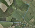
Track in Google Earth


Achievements
In OSM I labelled a cemetery and corrected the boundaries of the local residential area.
Sourcerer earned the OpenStreetMap achievement
|
Sourcerer earned the Midnight Geohash achievement
|
Expeditions and Plans
| 2015-11-11 | ||
|---|---|---|
| St. Gallen, Switzerland | Lysogeny | In a bush by a ditch in Konstanz, Germany. |
| Stuttgart, Germany | Steingesicht | Leinfelden-Echterdingen, Hainbuchenweg - a nice pedestrian and bicycle way.... |
| London East, United Kingdom | Flicky | In a field east of Epping in Essex. |
| Norwich, United Kingdom | Sourcerer | In a field north of Ringland, Norfolk, UK. |
Sourcerer's Expedition Links
2015-11-10 52 1 - 2015-11-11 52 1 - 2015-11-12 52 0 - KML file download of Sourcerer's expeditions for use with Google Earth.