Difference between revisions of "2015-11-28 52 1"
From Geohashing
imported>Sourcerer m ([live] Arrived) |
imported>Sourcerer m ([live picture] Proof. [http://www.openstreetmap.org/?lat=52.54820287&lon=1.06208503&zoom=16&layers=B000FTF @52.5482,1.0621]) |
||
| Line 26: | Line 26: | ||
== Photos == | == Photos == | ||
<gallery> | <gallery> | ||
| + | |||
| + | Image:2015-11-28_52_1_Sourcerer_1448668602853.jpg | Proof. [http://www.openstreetmap.org/?lat=52.54820287&lon=1.06208503&zoom=16&layers=B000FTF @52.5482,1.0621] | ||
</gallery> | </gallery> | ||
Revision as of 00:01, 28 November 2015
| Sat 28 Nov 2015 in 52,1: 52.5481804, 1.0620925 geohashing.info google osm bing/os kml crox |
Location
In a field north of Wymondham College, Norfolk, UK.
Participants
Plans
Expedition two of two spanning midnight - 2015-11-27 52 0 - 2015-11-28 52 1 - ETA 00:00.
Expedition
- Arrived -- Sourcerer (talk) @52.5482,1.0621 00:00, 28 November 2015 (GMT)
Photos
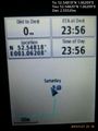
Proof. @52.5482,1.0621

Achievements
Expeditions and Plans
| 2015-11-28 | ||
|---|---|---|
| Dunkirk, New York | Pedalpusher | In the grass by the corner of Woodchuck Rd, on the edge of Seneca Nation Te... |
| McMinnville, Oregon | Jim | A field near Verboort, south of Hwy 26 |
| Stuttgart, Germany | Klaus | in the forest behind Waldhäuser-Ost, Tübingen |
| Norwich, United Kingdom | Sourcerer | In a field north of Wymondham College, Norfolk, UK. |
Sourcerer's Expedition Links
2015-11-27 52 0 - 2015-11-28 52 1 - 2015-11-29 52 1 - KML file download of Sourcerer's expeditions for use with Google Earth.