Difference between revisions of "2015-12-30 51 9"
imported>GeorgDerReisende (new report) |
imported>GeorgDerReisende (expedition report for Staufenberg-Escherode) |
||
| Line 1: | Line 1: | ||
| − | |||
| − | |||
| − | |||
| − | |||
| − | |||
| − | |||
| − | |||
| − | |||
| − | |||
| − | |||
{{meetup graticule | {{meetup graticule | ||
| lat=51 | | lat=51 | ||
| Line 19: | Line 9: | ||
== Location == | == Location == | ||
| − | + | ||
| + | The hash lay in the forest above Escherode. | ||
== Participants == | == Participants == | ||
| − | + | ||
| − | + | [[User:GeorgDerReisende|GeorgDerReisende]] | |
== Plans == | == Plans == | ||
| − | + | ||
| + | Taking the bus and walking to the hash. | ||
== Expedition == | == Expedition == | ||
| − | |||
| − | + | I left home at 11:10 and took the trams 3 and 4 and the bus 34 to Escherode, Kaufunger Waldweg. Then I walked to the hash. Mostly the way was on the track, which I took on the way home from [[2014-03-03 51 9]], and there it was: on the edge of that forest way. The pointer danced around like a wild animal, while I stood still and tried to find an accu with enough energy for my camera. Two pairs of them hadn't energy. Of course, they can be recharged for the next 967 times, but I don't think, they will have enough energy then for me. But at least I took the new ones and could work ahead. Took the usual photos. Then I walked back to Nieste and found some tracks in the wook, which didn't show on OSM and I mapped them. | |
| − | |||
== Photos == | == Photos == | ||
| − | |||
| − | |||
| − | |||
<gallery perrow="5"> | <gallery perrow="5"> | ||
| + | Image:2015-12-30 51 9 GeorgDerReisende 8374.jpg | proof | ||
| + | Image:2015-12-30 51 9 GeorgDerReisende 8376.jpg | at the green stump | ||
| + | Image:2015-12-30 51 9 GeorgDerReisende 8378.jpg | the east | ||
| + | Image:2015-12-30 51 9 GeorgDerReisende 8379.jpg | the north | ||
| + | Image:2015-12-30 51 9 GeorgDerReisende 8380.jpg | the west | ||
| + | Image:2015-12-30 51 9 GeorgDerReisende 8381.jpg | the south | ||
| + | Image:2015-12-30 51 9 GeorgDerReisende 8384.jpg | proof of dance of the pointer | ||
| + | Image:2015-12-30 51 9 GeorgDerReisende 8385.jpg | the geohasher | ||
</gallery> | </gallery> | ||
| Line 45: | Line 40: | ||
<!-- Add any achievement ribbons you earned below, or remove this section --> | <!-- Add any achievement ribbons you earned below, or remove this section --> | ||
| − | + | {{Déjà vu geohash | latitude = 51 | longitude = 9 | date = 2015-12-30 | olddate = 2014-03-03 | name = GeorgDerReisende }} | |
| − | |||
| − | |||
| − | + | {{OpenStreetMap achievement | latitude = 51 | longitude = 9 | date = 2015-12-30 | OSMlink = 36266197 }} | |
| − | |||
| − | |||
| − | |||
| − | + | [[Category:Expeditions]] | |
| − | |||
| − | |||
| − | |||
[[Category:Expeditions with photos]] | [[Category:Expeditions with photos]] | ||
| − | + | ||
| − | |||
| − | |||
| − | |||
| − | |||
[[Category:Coordinates reached]] | [[Category:Coordinates reached]] | ||
| − | |||
| − | |||
| − | |||
| − | |||
| − | |||
| − | |||
| − | |||
| − | |||
| − | |||
| − | |||
| − | |||
| − | |||
| − | |||
| − | |||
| − | |||
| − | |||
| − | |||
| − | |||
Revision as of 18:46, 30 December 2015
| Wed 30 Dec 2015 in 51,9: 51.3302846, 9.6976696 geohashing.info google osm bing/os kml crox |
Location
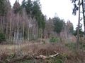
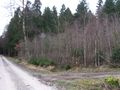
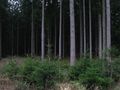
The hash lay in the forest above Escherode.
Participants
Plans
Taking the bus and walking to the hash.
Expedition
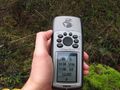
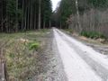
I left home at 11:10 and took the trams 3 and 4 and the bus 34 to Escherode, Kaufunger Waldweg. Then I walked to the hash. Mostly the way was on the track, which I took on the way home from 2014-03-03 51 9, and there it was: on the edge of that forest way. The pointer danced around like a wild animal, while I stood still and tried to find an accu with enough energy for my camera. Two pairs of them hadn't energy. Of course, they can be recharged for the next 967 times, but I don't think, they will have enough energy then for me. But at least I took the new ones and could work ahead. Took the usual photos. Then I walked back to Nieste and found some tracks in the wook, which didn't show on OSM and I mapped them.
Photos
proof
at the green stump
the east
the north
the west
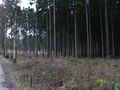
the south

proof of dance of the pointer
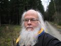
the geohasher


Achievements
GeorgDerReisende earned the Déjà Vu Geohash Achievement
|
This user earned the OpenStreetMap achievement
|