Difference between revisions of "2016-01-16 52 1"
From Geohashing
imported>Sourcerer m (→Planning) |
imported>Sourcerer m (→Added photo) |
||
| Line 27: | Line 27: | ||
Image:2016-01-16_52_1_Sourcerer_1452953388592.jpg | Arrival proof. [http://www.openstreetmap.org/?lat=52.52125204&lon=1.48197949&zoom=16&layers=B000FTF @52.5213,1.4820] | Image:2016-01-16_52_1_Sourcerer_1452953388592.jpg | Arrival proof. [http://www.openstreetmap.org/?lat=52.52125204&lon=1.48197949&zoom=16&layers=B000FTF @52.5213,1.4820] | ||
Image:2016-01-16_52_1_Sourcerer.jpg | Google Earth Track | Image:2016-01-16_52_1_Sourcerer.jpg | Google Earth Track | ||
| + | Image:2016-01-16 52 1 Sourcerer Close-by.jpg | Nearby View | ||
</gallery> | </gallery> | ||
Revision as of 20:12, 21 January 2016
| Sat 16 Jan 2016 in Norwich, UK: 52.5212689, 1.4820224 geohashing.info google osm bing/os kml crox |
Location
A field south of Loddon, Norfolk, UK.
Participants
Plans
The midnight plan was abandoned. Too much curry, beer and socialising - too late, too icy on the roads and most likely over the alcohol limit for driving. What fun.
Expedition
After plenty of sleep, in bright but chilly weather there was a short drive to the vicinity. There was a muddy ploughed field with the footpath well marked but soggy with mud and puddles. The hashpoint was a few paces off this path.
Photos
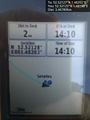
Arrival proof. @52.5213,1.4820
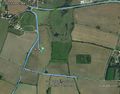
Google Earth Track
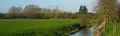
Nearby View


Achievements
Expeditions and Plans
| 2016-01-16 | ||
|---|---|---|
| Mannheim, Germany | Q-Owl, Q-Owla | In the northern part of Mannheim City on the roof of a company. |
| Norwich, United Kingdom | Sourcerer | A field south of Loddon, Norfolk, UK. |
| Turku, Finland | PPP | Very close to hedgefence in the left at the address Risukarhikuja 8, 21420 ... |
Sourcerer's Expedition Links
2016-01-15 52 1 - 2016-01-16 52 1 - 2016-01-21 52 1 - KML file download of Sourcerer's expeditions for use with Google Earth.