Difference between revisions of "2016-02-10 52 1"
From Geohashing
imported>Sourcerer m (→Planning) |
imported>Sourcerer m ([live picture] Arrival proof. [http://www.openstreetmap.org/?lat=52.22180486&lon=1.04183435&zoom=16&layers=B000FTF @52.2218,1.0418]) |
||
| Line 25: | Line 25: | ||
== Photos == | == Photos == | ||
<gallery perrow=4> | <gallery perrow=4> | ||
| + | |||
| + | Image:2016-02-10_52_1_Sourcerer_1455144522236.jpg | Arrival proof. [http://www.openstreetmap.org/?lat=52.22180486&lon=1.04183435&zoom=16&layers=B000FTF @52.2218,1.0418] | ||
</gallery> | </gallery> | ||
Revision as of 22:50, 10 February 2016
| Wed 10 Feb 2016 in Norwich, UK: 52.2217816, 1.0418432 geohashing.info google osm bing/os kml crox |
Location
A field south east of Gipping, 3km from source of the Gipping river, Suffolk, UK.
Participants
Plans
One of two spanning midnight - 2016-02-10 52 1 - 2016-02-11 52 1 - ETA 22:55.
Expedition
Photos
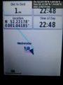
Arrival proof. @52.2218,1.0418

Achievements
Expeditions and Plans
| 2016-02-10 | ||
|---|---|---|
| Canberra, Australia | 1PE | Along the line of a dry creek in an urban park in the suburb of Florey, ACT... |
| Norwich, United Kingdom | Sourcerer | A field south east of Gipping, 3km from source of the Gipping river, Suffol... |
| Vantaa, Finland | Sgt pepper, UndeadPriest | In the hill crest in Viikki |
Sourcerer's Expedition Links
2016-02-03 52 1 - 2016-02-10 52 1 - 2016-02-11_52_1 - KML file download of Sourcerer's expeditions for use with Google Earth.