2016-02-11 52 1
| Thu 11 Feb 2016 in Norwich, UK: 52.1090362, 1.3089221 geohashing.info google osm bing/os kml crox |
Location
A field north of Woodbridge, Suffolk, UK.
Participants
Plans
This is probably a private garden but near enough to yesterday's to make it worth a look.
Two of two spanning midnight - 2016-02-10 52 1 - 2016-02-11 52 1 - ETA 00:00.
Expedition
There was a lay-by to park 250 metres from the hashpoint. The walk was longer because farm buildings had to be circumnavigated. There were well maintained hedges, 4 metres high. With fading hope, the field entrance was located. There was a low rabbit fence, easy for a human to hop over. The tall hedge was still present on the right. The grassy meadow changed to oil seed rape seedlings but it was easier to follow the perimeter path. Then joy of joys. The tall hedge ended and there was a wooden fence with the horizontal beams just the right hight for a quick squeeze through. The hashpoint was in a garden, as expected but quite far from the house and no-one got disturbed. I made a screen shot to minimise my trespass time and started my escape at exactly midnight.
Photos
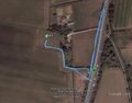
Google Earth Track
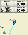
Screen Shot Proof


Achievements
Expeditions and Plans
| 2016-02-11 | ||
|---|---|---|
| Norwich, United Kingdom | Sourcerer | A field north of Woodbridge, Suffolk, UK. |
| Utrecht, Netherlands | xnyhps | Near Soesterberg. |
Sourcerer's Expedition Links
2016-02-10 52 1 - 2016-02-11 52 1 - 2016-02-12 52 1 - KML file download of Sourcerer's expeditions for use with Google Earth.