2016-02-12 52 1
| Fri 12 Feb 2016 in Norwich, UK: 52.4185127, 1.5528699 geohashing.info google osm bing/os kml crox |
Location
A wood south of Beccles, Suffolk, UK.
Participants
Plans
One of two spanning midnight - 2016-02-12 52 1 - 2016-02-13 52 1 - ETA 22:45.
Expedition
The ground was damp after earlier rain but the sky had cleared. There was bright starlight and the temperature was dropping fast. A public footpath led across the middle of a field but it had been ploughed up. The perimeter path was a better option. There was a way into the wood, possibly made by deer. Daffodils were in bud under the trees so a bit of care was needed to avoid these. It was easy enough to zero the distance on my Garmin GPSr. My Android phone lost GPS lock and said I was 1.5km away! The picture uploaded worked OK in spite of the trees.
Photos
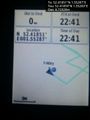
Arrival proof.
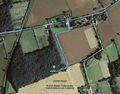
Google Earth Track.


Achievements
Expeditions and Plans
| 2016-02-12 | ||
|---|---|---|
| Zürich, Switzerland | Chris 47 8, Calamus | In Zürich Oerlikon, close to Leutschenpark. |
| Mannheim, Germany | DODO | In the Rheinauer forest near a bridlepath. |
| Würzburg, Germany | Klaus | between Unter- and Oberwittstadt, hopefully not IN the Hasselbach |
| Kassel, Germany | GeorgDerReisende | The hash lay one kilometer east of Holzhausen in the forest. |
| Birmingham, United Kingdom | Pbro | In wide central divider of Allesley Old Road, Coventry. The hash is in a bu... |
| Norwich, United Kingdom | Sourcerer | A wood south of Beccles, Suffolk, UK. |
| Hannover, Germany | Fippe | located between the Blauer See and the Leine in Garbsen. |
Sourcerer's Expedition Links
2016-02-11 52 1 - 2016-02-12 52 1 - 2016-02-13 52 1 - KML file download of Sourcerer's expeditions for use with Google Earth.