Difference between revisions of "2016-04-11 49 8"
From Geohashing
imported>Q-Owl (Created page with "thumb|left|nnnnn {{meetup graticule | lat=49 | lon=8 | date=2016-04-11 }}__NOTOC__ == Location == In the upper Rhine valley between wikip...") |
imported>Q-Owl (→Achievements / Honorable Mention) |
||
| Line 54: | Line 54: | ||
| name = Q-Owl & Q-Owla | | name = Q-Owl & Q-Owla | ||
}} | }} | ||
| + | {{Radio Yerevan | ||
| + | | achievement = Hash collision | ||
| + | | detail = the cache GC1TA93 (about 30 m distance in direct sight) wasn't there today and found by me already two years ago | ||
| + | | latitude = 49 | ||
| + | | longitude = 8 | ||
| + | | date = 2016-04-11 | ||
| + | | name = Q-Owl | ||
| + | }} | ||
<!-- | <!-- | ||
Have I really been the only one? | Have I really been the only one? | ||
| Line 62: | Line 70: | ||
| name = [[User:Q-Owl|Q-Owl]] | | name = [[User:Q-Owl|Q-Owl]] | ||
}} --> | }} --> | ||
| − | |||
| − | |||
== Other Geohashing Expeditions and Plans on this Day == | == Other Geohashing Expeditions and Plans on this Day == | ||
Revision as of 06:56, 12 April 2016

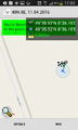
| Mon 11 Apr 2016 in 49,8: 49.5986799, 8.6016925 geohashing.info google osm bing/os kml crox |
Location
In the upper Rhine valley between Hemsbach and Hüttenfeld.
Participants
Plan
Quick decision after work: Drive near the hashpoint, find it, walk back to the car, find some geocaches and drive home.
Expedition
We drove near the hashpoint and found it on a field next to a path. I walked careful from the path to the hashpoint, marked it with a little stick, took a few photos and walked back on traktor tracks.
Later we found a few geocaches and so we had two nice hours outside.
Photos
Proof
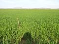
View E
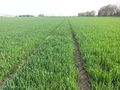
View N
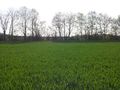
View W
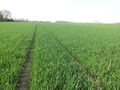
View S
Grin


Achievements / Honorable Mention
Q-Owl & Q-Owla earned the Land geohash achievement
|
Is it true that this user earned the Hash collision?
|
Other Geohashing Expeditions and Plans on this Day
Expeditions and Plans
| 2016-04-11 | ||
|---|---|---|
| Mannheim, Germany | Q-Owl, Q-Owla | In the upper Rhine valley between Hemsbach and Hüttenfeld. |
| Norwich, United Kingdom | Sourcerer | In a field about 40 metres from the Weaver's Way footpath, east of Halverga... |