Difference between revisions of "2016-06-11 52 1"
imported>Sourcerer (An expedition message sent via Geohash Droid for Android.) |
imported>Sourcerer m (→New expedition) |
||
| Line 1: | Line 1: | ||
| − | + | {{meetup graticule | |
| − | |||
| − | |||
| − | |||
| − | |||
| − | |||
| − | |||
| − | |||
| − | |||
| − | |||
| − | {{meetup graticule | ||
| lat=52 | | lat=52 | ||
| lon=1 | | lon=1 | ||
| date=2016-06-11 | | date=2016-06-11 | ||
| + | | graticule_name=Norwich, UK | ||
| + | | graticule_link=Norwich, United Kingdom | ||
}} | }} | ||
| + | __NOTOC__ | ||
| + | == Location == | ||
| − | + | In a wheat field adjacent to Tunstall Forest, north of Chillesford, Suffolk, UK. | |
| − | + | ||
| + | == Plans == | ||
| − | + | Sourcerer decided to tick this one off before most of the population were up and about. | |
| − | |||
== Participants == | == Participants == | ||
| − | |||
| − | |||
| − | + | [[User:Sourcerer|Sourcerer]] | |
| − | |||
== Expedition == | == Expedition == | ||
| − | |||
| − | + | Drive, walk, shuffle, walk, drive. This one was easy. Most of the walk was in the pleasant early summer woodland of Tunstall Forest. The wheat field had been flooded earlier in the year leading a patch almost devoid of vegetation. The hashpoint was in the middle of this zone. Healthy looking wheat surrounded the damp patch. The traffic was beginning to build up as Sourcerer neared the end of the expedition. | |
| − | |||
== Photos == | == Photos == | ||
| − | < | + | |
| − | Image: | + | <gallery perrow="3"> |
| − | -- | + | Image:2016-06-11 52 1 Sourcerer Proof.jpg | Proof |
| − | + | Image:2016-06-11 52 1 Sourcerer Track.jpg | Google Earth Track | |
| + | Image:2016-06-11 52 1 Sourcerer HP1.jpg | The Hashpoint | ||
| + | Image:2016-06-11 52 1 Sourcerer HP2.jpg | The Hashpoint | ||
| + | Image:2016-06-11 52 1 Sourcerer HP3.jpg | The Hashpoint | ||
| + | Image:2016-06-11 52 1 Sourcerer HP4.jpg | The Hashpoint | ||
</gallery> | </gallery> | ||
== Achievements == | == Achievements == | ||
{{#vardefine:ribbonwidth|800px}} | {{#vardefine:ribbonwidth|800px}} | ||
| − | |||
| − | + | {{Sourcerer_links | |
| − | + | | prev = 2016-06-10 52 1 | |
| − | + | | curr = 2016-06-11 52 1 | |
| − | + | | next = 2016-06-12 52 1 | |
| − | + | | date = 2016-06-11 | |
| − | + | }} | |
| − | |||
| − | |||
| − | |||
| − | -- | ||
| − | |||
| − | |||
| − | |||
[[Category:Expeditions]] | [[Category:Expeditions]] | ||
| − | |||
[[Category:Expeditions with photos]] | [[Category:Expeditions with photos]] | ||
| − | |||
| − | |||
| − | |||
| − | |||
| − | |||
[[Category:Coordinates reached]] | [[Category:Coordinates reached]] | ||
| − | |||
| − | |||
| − | |||
| − | |||
| − | |||
| − | |||
| − | |||
| − | |||
| − | |||
| − | |||
| − | |||
| − | |||
| − | |||
| − | |||
| − | |||
| − | |||
| − | |||
| − | |||
Revision as of 11:29, 11 June 2016
| Sat 11 Jun 2016 in Norwich, UK: 52.1232080, 1.4848987 geohashing.info google osm bing/os kml crox |
Location
In a wheat field adjacent to Tunstall Forest, north of Chillesford, Suffolk, UK.
Plans
Sourcerer decided to tick this one off before most of the population were up and about.
Participants
Expedition
Drive, walk, shuffle, walk, drive. This one was easy. Most of the walk was in the pleasant early summer woodland of Tunstall Forest. The wheat field had been flooded earlier in the year leading a patch almost devoid of vegetation. The hashpoint was in the middle of this zone. Healthy looking wheat surrounded the damp patch. The traffic was beginning to build up as Sourcerer neared the end of the expedition.
Photos
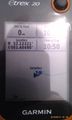
Proof
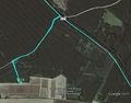
Google Earth Track
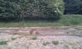
The Hashpoint
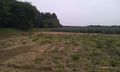
The Hashpoint
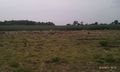
The Hashpoint
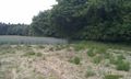
The Hashpoint


Achievements
Expeditions and Plans
| 2016-06-11 | ||
|---|---|---|
| Norwich, United Kingdom | Sourcerer | In a wheat field adjacent to Tunstall Forest, north of Chillesford, Suffolk... |
| Nurmes, Finland | Tilley, Mrs. Tilley, Our daughter | In Konttisenkangas, Juuka, Finland. The point lies in a forest with ongoing... |
Sourcerer's Expedition Links
2016-06-10 52 1 - 2016-06-11 52 1 - 2016-06-12 52 1 - KML file download of Sourcerer's expeditions for use with Google Earth.