Difference between revisions of "2016-06-22 42 -78"
imported>Pedalpusher (summary, ribbons added) |
imported>Pedalpusher (added pictures) |
||
| Line 12: | Line 12: | ||
After work I watered the garden as it's been pretty dry around here lately. I got the dogs set up in the house and grabbed my fixed-gear and rode off to the hash. With experience from previous hashes, I knew when to expect my turns and made it with no trouble to the hash. I stopped in the neighboring driveway just off the sidewalk and as I stopped, my GPS read 0.00 feet to go, but by the time I got my camera ready, it climbed up slightly. Getting my pictures, I made a Left two houses up to ride into the field by the school. Normally, (according to the geocache page) it's pretty damp back there, but without much rain, I was actually able to ride my bike almost right to the cache. It was like fixed gear cyclocross (definitely not recommended IRL) for a minute there. | After work I watered the garden as it's been pretty dry around here lately. I got the dogs set up in the house and grabbed my fixed-gear and rode off to the hash. With experience from previous hashes, I knew when to expect my turns and made it with no trouble to the hash. I stopped in the neighboring driveway just off the sidewalk and as I stopped, my GPS read 0.00 feet to go, but by the time I got my camera ready, it climbed up slightly. Getting my pictures, I made a Left two houses up to ride into the field by the school. Normally, (according to the geocache page) it's pretty damp back there, but without much rain, I was actually able to ride my bike almost right to the cache. It was like fixed gear cyclocross (definitely not recommended IRL) for a minute there. | ||
| − | Finding the VERY pink cache, I signed and took some more pictures for the hash collision ribbon and cruised out by the school and off to dinner. I rode down a pretty busy road to La Tolteca (clearly a Mexican place) where I had a beer and Quesadillas. Looking for a quieter route home, I hit a less busy road going by ECC (community college) where I stopped to find another cache that has been sitting in my GPS for a long time. Unfortunately, it was IN the lamp post, and I had neither the tools nor the desire to open it so I moved on. | + | Finding the VERY pink cache, I signed and took some more pictures for the hash collision ribbon and cruised out by the school and off to dinner. I rode down a pretty busy road to La Tolteca (clearly a Mexican place) where I had a beer and Quesadillas. Looking for a quieter route home, I hit a less busy road going by ECC (community college) where I stopped to find another cache that has been sitting in my GPS for a long time. Unfortunately, I believe it was IN the lamp post, and I had neither the tools nor the desire to open it so I moved on. |
Moseying on, I passed a cemetery and decided since I was on an easy going tour of town, I'd swing in and ride through. It was a newer cemetery without a really old section, but was still very nice. There was a large pond too with a family feeding the fish within as I rode by. | Moseying on, I passed a cemetery and decided since I was on an easy going tour of town, I'd swing in and ride through. It was a newer cemetery without a really old section, but was still very nice. There was a large pond too with a family feeding the fish within as I rode by. | ||
| Line 19: | Line 19: | ||
== Photos == | == Photos == | ||
| − | <gallery perrow=" | + | <gallery perrow="4"> |
| − | Image: | + | Image: 2016-06-22 gps.jpg | Made it! Just not quite fast enough with the camera though. |
| − | Image: | + | Image: 2016-06-22 gps2.jpg| Accuracy. |
| − | Image: | + | Image: 2016-06-22 hash.jpg | View of the hash. I believe it's somewhere along the shadow of the tree trunk in the grass by the shade. |
| − | Image: | + | Image: 2016-06-22 stupidNonGrin.jpg | Oops, forgot to smile. The un-standard Stupid Non-Grin then, sorry. |
| − | Image: | + | Image: 2016-06-22 viewWest.jpg | Looking west, there is my Left turn to the Field by the geocache. |
| − | Image: | + | Image: 2016-06-22 distToCache.jpg | Distance to the cache, from the hash. |
| − | Image: | + | Image: 2016-06-22 pinkCache.jpg | Found it! |
| − | Image: | + | Image: 2016-06-22 distToHash.jpg | Distance to the hash, from the cache. |
</gallery> | </gallery> | ||
| Line 36: | Line 36: | ||
| date = 2016-06-22 | | date = 2016-06-22 | ||
}} | }} | ||
| + | {{bicycle geohash | ||
| + | | latitude = 42 | ||
| + | | longitude = -78 | ||
| + | | date = 2016-06-22 | ||
| + | | name = Pedalpusher | ||
| + | }} | ||
{{Hash collision | {{Hash collision | ||
| latitude = 42 | | latitude = 42 | ||
| Line 43: | Line 49: | ||
| id = GC3XMG4 | | id = GC3XMG4 | ||
| link = https://www.geocaching.com/geocache/GC3XMG4_pink-in-the-park | | link = https://www.geocaching.com/geocache/GC3XMG4_pink-in-the-park | ||
| − | | distance = 0. | + | | distance = 0.16 Miles |
| honor = honorable mention (optional) | | honor = honorable mention (optional) | ||
}} | }} | ||
| − | |||
[[Category:Expeditions]] | [[Category:Expeditions]] | ||
[[Category:Coordinates reached]] | [[Category:Coordinates reached]] | ||
| − | + | [[Category:Expeditions with photos]] | |
Revision as of 01:28, 23 June 2016
| Wed 22 Jun 2016 in 42,-78: 42.7676707, -78.8359901 geohashing.info google osm bing/os kml crox |
Location
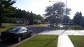
A front lawn, by the sidewalk on Sheva Lane
Participants
Expedition
This hash was very close to the Tron Hash I did on 2015-08-13. I could have done a Tron here too as I had access to the same field, but I wanted to stop and eat on the way home so that was out. There was a geocache in the woods by the school fields which made it another Hash-Collision honorable mention as well.
After work I watered the garden as it's been pretty dry around here lately. I got the dogs set up in the house and grabbed my fixed-gear and rode off to the hash. With experience from previous hashes, I knew when to expect my turns and made it with no trouble to the hash. I stopped in the neighboring driveway just off the sidewalk and as I stopped, my GPS read 0.00 feet to go, but by the time I got my camera ready, it climbed up slightly. Getting my pictures, I made a Left two houses up to ride into the field by the school. Normally, (according to the geocache page) it's pretty damp back there, but without much rain, I was actually able to ride my bike almost right to the cache. It was like fixed gear cyclocross (definitely not recommended IRL) for a minute there.
Finding the VERY pink cache, I signed and took some more pictures for the hash collision ribbon and cruised out by the school and off to dinner. I rode down a pretty busy road to La Tolteca (clearly a Mexican place) where I had a beer and Quesadillas. Looking for a quieter route home, I hit a less busy road going by ECC (community college) where I stopped to find another cache that has been sitting in my GPS for a long time. Unfortunately, I believe it was IN the lamp post, and I had neither the tools nor the desire to open it so I moved on.
Moseying on, I passed a cemetery and decided since I was on an easy going tour of town, I'd swing in and ride through. It was a newer cemetery without a really old section, but was still very nice. There was a large pond too with a family feeding the fish within as I rode by.
All in all, it was a very enjoyable expedition.
Photos
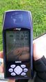
Made it! Just not quite fast enough with the camera though.
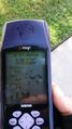
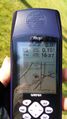
Accuracy.
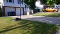
View of the hash. I believe it's somewhere along the shadow of the tree trunk in the grass by the shade.
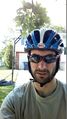
Oops, forgot to smile. The un-standard Stupid Non-Grin then, sorry.
Looking west, there is my Left turn to the Field by the geocache.
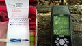
Distance to the cache, from the hash.
Found it!
Distance to the hash, from the cache.


Ribbons
This user earned the Land geohash achievement
|
Pedalpusher earned the Bicycle geohash achievement
|
Pedalpusher earned the Hash collision honorable mention
|