Difference between revisions of "2016-08-20 51 9"
imported>GeorgDerReisende (new report) |
imported>GeorgDerReisende (expedition report for Niedenstein-Kirchberg) |
||
| Line 1: | Line 1: | ||
| − | |||
| − | |||
| − | |||
| − | |||
| − | |||
| − | |||
| − | |||
| − | |||
| − | |||
| − | |||
{{meetup graticule | {{meetup graticule | ||
| lat=51 | | lat=51 | ||
| Line 19: | Line 9: | ||
== Location == | == Location == | ||
| − | + | ||
| + | The hash lay on the side of a field north of Niedenstein-Kirchberg. | ||
== Participants == | == Participants == | ||
| − | + | ||
| − | + | [[User:GeorgDerReisende|GeorgDerReisende]] | |
== Plans == | == Plans == | ||
| − | + | ||
| + | Hitchhiking to Kirchberg and walking to the hash. | ||
== Expedition == | == Expedition == | ||
| − | |||
| − | + | I left home at 12:55 and traveled by tram to Baunatal. From there I hitchhiked to Kirchberg with two cars and arrived there at 3 o'clock. I could walk the 400 meters to the hash and wait there for one hour for the xkcd meetup, but I thought I could make a walk around the fields. But I took so many photos, that I arrived a little bit late at the hash. But not too late. The hash lay on the green field eight meters south of the way. Afterwards I walked around the village, to the church and onto the hill. | |
| − | |||
== Photos == | == Photos == | ||
| Line 39: | Line 29: | ||
--> | --> | ||
<gallery perrow="5"> | <gallery perrow="5"> | ||
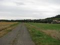
| + | Image:2016-08-20 51 9 GeorgDerReisende 1694.jpg | the hash lay on the right side of the way | ||
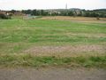
| + | Image:2016-08-20 51 9 GeorgDerReisende 1695.jpg | the hash lay 8 meters south | ||
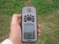
| + | Image:2016-08-20 51 9 GeorgDerReisende 1696.jpg | proof | ||
| + | Image:2016-08-20 51 9 GeorgDerReisende 1698.jpg | north | ||
| + | Image:2016-08-20 51 9 GeorgDerReisende 1699.jpg | east | ||
| + | Image:2016-08-20 51 9 GeorgDerReisende 1700.jpg | south | ||
| + | Image:2016-08-20 51 9 GeorgDerReisende 1701.jpg | west | ||
| + | Image:2016-08-20 51 9 GeorgDerReisende 1702.jpg | the geohasher | ||
| + | Image:2016-08-20 51 9 GeorgDerReisende 1772.jpg | look from the church to the hash | ||
</gallery> | </gallery> | ||
| Line 45: | Line 44: | ||
<!-- Add any achievement ribbons you earned below, or remove this section --> | <!-- Add any achievement ribbons you earned below, or remove this section --> | ||
| − | + | {{XKCD Centurion | count = 32 | name = GeorgDerReisende }} | |
| − | |||
| − | |||
| − | + | [[Category:Expeditions]] | |
| − | + | [[Category:Expeditions with photos]] | |
| − | |||
| − | [[Category: | ||
| − | |||
| − | |||
| − | |||
| − | |||
| − | |||
| − | |||
| − | |||
| − | |||
| − | |||
| − | |||
| − | |||
| − | |||
[[Category:Coordinates reached]] | [[Category:Coordinates reached]] | ||
| − | |||
| − | |||
| − | |||
| − | |||
| − | |||
| − | |||
| − | |||
| − | |||
| − | |||
| − | |||
| − | |||
| − | |||
| − | |||
| − | |||
| − | |||
| − | |||
| − | |||
| − | |||
Revision as of 22:39, 21 August 2016
| Sat 20 Aug 2016 in 51,9: 51.2013648, 9.2970473 geohashing.info google osm bing/os kml crox |
Location
The hash lay on the side of a field north of Niedenstein-Kirchberg.
Participants
Plans
Hitchhiking to Kirchberg and walking to the hash.
Expedition
I left home at 12:55 and traveled by tram to Baunatal. From there I hitchhiked to Kirchberg with two cars and arrived there at 3 o'clock. I could walk the 400 meters to the hash and wait there for one hour for the xkcd meetup, but I thought I could make a walk around the fields. But I took so many photos, that I arrived a little bit late at the hash. But not too late. The hash lay on the green field eight meters south of the way. Afterwards I walked around the village, to the church and onto the hill.
Photos
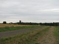
the hash lay on the right side of the way
the hash lay 8 meters south
proof
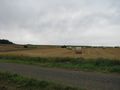
north
east
south
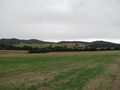
west
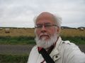
the geohasher
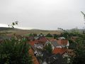
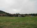
look from the church to the hash


Achievements
GeorgDerReisende earned the xkcd Triginturion achievement
|