Difference between revisions of "2016-10-28 52 1"
From Geohashing
imported>Sourcerer m (→New expedition) |
imported>FippeBot m (Location) |
||
| Line 50: | Line 50: | ||
[[Category:Expeditions with photos]] | [[Category:Expeditions with photos]] | ||
[[Category:Coordinates reached]] | [[Category:Coordinates reached]] | ||
| + | {{location|GB|ENG|SFK}} | ||
Latest revision as of 01:40, 16 August 2019
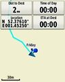
| Fri 28 Oct 2016 in Norwich, UK: 52.3761244, 1.4524936 geohashing.info google osm bing/os kml crox |
Location
A field east of Rumburgh, Suffolk, UK.
Participants
Plans
Two of two spanning midnight 2016-10-27 52 1 - 2016-10-28 52 1 - ETA 00:00.
Expedition
There was parking in the rural residential road. A track led past flood lit barns. The hashpoint was a few paces into the field at the end of the track. I felt a bit like Fat Freddie's cat in the concentration camp. I had an urge to do a small dance in the flood lights.
Photos
- Photo Gallery
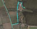
Google Earth Track
Proof


Achievements
Sourcerer earned the Midnight Geohash achievement
|
Expeditions and Plans
| 2016-10-28 | ||
|---|---|---|
| Buffalo, New York | Pedalpusher | Next to a fence off Hertel by the intersection of Elmwood in Buffalo |
| Mannheim, Germany | DODO | A street in Otterstadt. |
| Norwich, United Kingdom | Sourcerer | A field east of Rumburgh, Suffolk, UK. |
Sourcerer's Expedition Links
2016-10-27 52 1 - 2016-10-28 52 1 - 2016-11-02 52 1 - KML file download of Sourcerer's expeditions for use with Google Earth.