Difference between revisions of "2017-03-10 -37 144"
imported>Thunk ([live picture]Hashpoint reached by wading and then treading water. Pictures and proof below. [http://www.openstreetmap.org/?lat=-37.81282250&lon=144.97163770&zoom=16&layers=B000FTF @-37.8128,144.9716]) |
imported>Thunk |
||
| Line 16: | Line 16: | ||
<!-- edit as necessary --> | <!-- edit as necessary --> | ||
| − | |||
== Location == | == Location == | ||
| − | + | 20 meters offshore a rock breakwater, near Hampton Beach, Port Phillip Bay, Victoria, Australia | |
== Participants == | == Participants == | ||
| − | + | [[User:Thunk|Thunk]] ([[User talk:Thunk|talk]]) | |
| − | |||
== Plans == | == Plans == | ||
| − | + | Hey, a hashpoint very near a beach that I could probably swim to. The beach itself is near a commuter rail line, too. How convenient, considering I don't want to leave this continent without getting Globetrotter. | |
== Expedition == | == Expedition == | ||
| − | + | I left the place where I was staying, and easily reached the beach. Changing clothes and wading toward the hashpoint revealed that it was in a region of relative shallows, about 1 m depth (or to my waist). The only problem was providing proof using only a water-sensitive phone... | |
| + | |||
| + | So I walked down the beach to the Sandringham Yacht Club. A store there sold a waterproof tablet cover...for $70! Too much. So I left the beach and found a corner gas station which sold small plastic bags for $4. Double-bagging the phone would do nicely. | ||
| + | |||
| + | So it was back to the beach, bagged phone in hand, being careful not to drop it. Wading out and doing the hashdance went smoothly, and I headed back...only to realise I forgot to take pictures. Which I promptly did, even though the bag resulted in substantial blur. | ||
| + | It was also important to make this an actual Water Geohash, even though wading would not ordinarily qualify. So I leaned back for a few seconds at the point to float. Which caused me to leave thoroughly wet. | ||
| + | |||
| + | Then, it was time to walk along the beach, change clothes, go to the city to eat dinner, than procrastinate some more. | ||
== Tracklog == | == Tracklog == | ||
| Line 35: | Line 40: | ||
== Photos == | == Photos == | ||
| − | |||
| − | |||
| − | |||
<gallery perrow="5"> | <gallery perrow="5"> | ||
| − | Image:2017-03-10_-37_144_thunk_1489133771852.jpg| | + | Image:2017-03-10_-37_144_thunk_1489133771852.jpg|View of beach from hashpoint. |
</gallery> | </gallery> | ||
| + | |||
== Achievements == | == Achievements == | ||
{{#vardefine:ribbonwidth|800px}} | {{#vardefine:ribbonwidth|800px}} | ||
| − | + | {{water geohash | latitude = -37 | longitude = 144 | date = 2017-03-10 | name = thunk | vehicle = flotation}} | |
| + | {{Public transport geohash | latitude = -37 | longitude = 144 | date = 2017-03-10 | busline = PTV | name = thunk }} | ||
| + | {{Globetrotter6 | ||
| + | |||
| + | | name = thunk | ||
| + | | northamerica = true | ||
| + | | europe = | ||
| + | | africa = | ||
| + | | southamerica = | ||
| + | | australia = true | ||
| + | | europe = | ||
| + | | asia = | ||
| + | | continents = 2 | ||
| + | }} | ||
<!-- =============== USEFUL CATEGORIES FOLLOW ================ | <!-- =============== USEFUL CATEGORIES FOLLOW ================ | ||
Delete the next line ONLY if you have chosen the appropriate categories below. If you are unsure, don't worry. People will read your report and help you with the classification. --> | Delete the next line ONLY if you have chosen the appropriate categories below. If you are unsure, don't worry. People will read your report and help you with the classification. --> | ||
| − | |||
<!-- ==REQUEST FOR TWITTER BOT== Please leave either the New report or the Expedition planning category in as long as you work on it. This helps the twitter bot a lot with announcing the right outcome at the right moment. --> | <!-- ==REQUEST FOR TWITTER BOT== Please leave either the New report or the Expedition planning category in as long as you work on it. This helps the twitter bot a lot with announcing the right outcome at the right moment. --> | ||
| Line 55: | Line 70: | ||
<!-- Potential categories. Please include all the ones appropriate to your expedition --> | <!-- Potential categories. Please include all the ones appropriate to your expedition --> | ||
<!-- If this is a planning page: | <!-- If this is a planning page: | ||
| − | |||
--> | --> | ||
| Line 64: | Line 78: | ||
-- and one or more of -- | -- and one or more of -- | ||
[[Category:Expeditions with photos]] | [[Category:Expeditions with photos]] | ||
| − | |||
[[Category:Expedition without GPS]] | [[Category:Expedition without GPS]] | ||
--> | --> | ||
| Line 70: | Line 83: | ||
<!-- if you reached your coords: | <!-- if you reached your coords: | ||
[[Category:Coordinates reached]] | [[Category:Coordinates reached]] | ||
| − | |||
| − | |||
| − | |||
| − | |||
| − | |||
| − | |||
| − | |||
| − | |||
| − | |||
| − | |||
| − | |||
| − | |||
| − | |||
| − | |||
| − | |||
| − | |||
| − | |||
| − | |||
Revision as of 11:47, 10 March 2017
| Fri 10 Mar 2017 in -37,144: -37.9397874, 144.9981420 geohashing.info google osm bing/os kml crox |
Location
20 meters offshore a rock breakwater, near Hampton Beach, Port Phillip Bay, Victoria, Australia
Participants
Plans
Hey, a hashpoint very near a beach that I could probably swim to. The beach itself is near a commuter rail line, too. How convenient, considering I don't want to leave this continent without getting Globetrotter.
Expedition
I left the place where I was staying, and easily reached the beach. Changing clothes and wading toward the hashpoint revealed that it was in a region of relative shallows, about 1 m depth (or to my waist). The only problem was providing proof using only a water-sensitive phone...
So I walked down the beach to the Sandringham Yacht Club. A store there sold a waterproof tablet cover...for $70! Too much. So I left the beach and found a corner gas station which sold small plastic bags for $4. Double-bagging the phone would do nicely.
So it was back to the beach, bagged phone in hand, being careful not to drop it. Wading out and doing the hashdance went smoothly, and I headed back...only to realise I forgot to take pictures. Which I promptly did, even though the bag resulted in substantial blur. It was also important to make this an actual Water Geohash, even though wading would not ordinarily qualify. So I leaned back for a few seconds at the point to float. Which caused me to leave thoroughly wet.
Then, it was time to walk along the beach, change clothes, go to the city to eat dinner, than procrastinate some more.
Tracklog
Photos
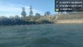
View of beach from hashpoint.

Achievements
thunk earned the Water geohash achievement
|
thunk earned the Public transport geohash achievement
|
thunk earned the Globetrotter achievement
|