Difference between revisions of "2017-04-01 48 11"
imported>Solli |
imported>Solli |
||
| Line 18: | Line 18: | ||
== Expedition == | == Expedition == | ||
| − | + | Short Story: I grabbed my bike, went there, took photos, went back. | |
| + | |||
| + | Longer story: Since the hash was so close I had several possibilities to get there: Hiking, hiking barefoot in hobbit style,... But in the end I chose the most convenient method and took the bike. One way distance was 3 km. The hash itself was in a field which was unfortunately freshly sown. I walked along the hedge and was just 10 m away from the coordinates when I had to choose what to do now: Give up or enter the field. But since it was only 10 m and the wheat barely sprouted anyway I decided to go (or rather tip-toe) there anyway. Then I took some photoes, tip-toed back, took the bike and went home. | ||
== Photos == | == Photos == | ||
| − | |||
| − | |||
<gallery perrow="5"> | <gallery perrow="5"> | ||
| + | Image:2017-04-01 48 11 Solli 01.png | Sitting on my couch... | ||
| + | Image:2017-04-01 48 11 Solli 02.jpg | The hash-field | ||
| + | Image:2017-04-01 48 11 Solli 03.jpg | There I am, out standing in my field | ||
| + | Image:2017-04-01 48 11 Solli 04.png | Proof | ||
| + | Image:2017-04-01 48 11 Solli 05.jpg | My bike | ||
</gallery> | </gallery> | ||
| − | |||
| − | |||
== Achievements == | == Achievements == | ||
| − | {{ | + | {{land geohash |
| − | + | | latitude = 48 | |
| − | + | | longitude = 11 | |
| − | + | | date = 2017-04-01 | |
| − | + | | name = Solli | |
| − | + | }} | |
| − | |||
| − | |||
| − | + | {{bicycle geohash | |
| − | + | | latitude = 48 | |
| − | + | | longitude = 11 | |
| − | -- | + | | date = 2017-04-01 |
| + | | name = Solli | ||
| + | | distance = 6 km | ||
| + | | bothways = true | ||
| + | | image = 2017-04-01 48 11 Solli 05.jpg | ||
| + | }} | ||
| − | + | {{Last man standing | |
| + | | latitude = 48 | ||
| + | | longitude = 11 | ||
| + | | date = 2017-04-01 | ||
| + | | name = Solli | ||
| + | }} | ||
| − | |||
[[Category:Expeditions]] | [[Category:Expeditions]] | ||
| − | |||
[[Category:Expeditions with photos]] | [[Category:Expeditions with photos]] | ||
| − | |||
| − | |||
| − | |||
| − | |||
| − | |||
[[Category:Coordinates reached]] | [[Category:Coordinates reached]] | ||
| − | |||
| − | |||
| − | |||
| − | |||
| − | |||
| − | |||
| − | |||
| − | |||
| − | |||
| − | |||
| − | |||
| − | |||
| − | |||
| − | |||
| − | |||
| − | |||
| − | |||
| − | |||
Revision as of 09:46, 7 April 2017
| Sat 1 Apr 2017 in 48,11: 48.1526595, 11.7116414 geohashing.info google osm bing/os kml crox |
Location
On a field between Aschheim, Feldkirchen and the Munich trade fair centre.
Participants
Plans
When I checked the coordinates while sitting on my couch I was quite surprised: The hashpoint was only 2 km away!
Expedition
Short Story: I grabbed my bike, went there, took photos, went back.
Longer story: Since the hash was so close I had several possibilities to get there: Hiking, hiking barefoot in hobbit style,... But in the end I chose the most convenient method and took the bike. One way distance was 3 km. The hash itself was in a field which was unfortunately freshly sown. I walked along the hedge and was just 10 m away from the coordinates when I had to choose what to do now: Give up or enter the field. But since it was only 10 m and the wheat barely sprouted anyway I decided to go (or rather tip-toe) there anyway. Then I took some photoes, tip-toed back, took the bike and went home.
Photos
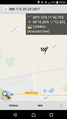
Sitting on my couch...
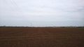
The hash-field
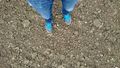
There I am, out standing in my field
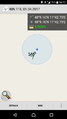
Proof
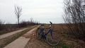
My bike


Achievements
Solli earned the Land geohash achievement
|
Solli earned the Bicycle geohash achievement
|
Solli earned the Last man standing achievement
|