Difference between revisions of "2017-06-04 49 11"
imported>Paintedhell (Created page with "{{meetup graticule | lat=49 | lon=11 | date=2017-06-04 }} __NOTOC__ == Location == In the forest near the road between Aufseß and Draisendorf, Franconia. == Participants =...") |
imported>FippeBot m (Location) |
||
| Line 28: | Line 28: | ||
[[Category:Expeditions with photos]] | [[Category:Expeditions with photos]] | ||
[[Category:Coordinates reached]] | [[Category:Coordinates reached]] | ||
| + | {{location|DE|BY|FO}} | ||
Latest revision as of 02:36, 16 August 2019
| Sun 4 Jun 2017 in 49,11: 49.8667543, 11.2459594 geohashing.info google osm bing/os kml crox |
Location
In the forest near the road between Aufseß and Draisendorf, Franconia.
Participants
- Juja and three very visible ninjas
Expedition
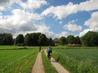
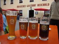
I used the Whitsun weekend to go for a short trip to Franconia with some friends for cycling and beer tasting, and luckily I checked the coordinates on Friday and found the Sunday coordinate to be in a location that was nice enough so I could maybe persuade five people to do a short detour for my stupid hobbies. Even more luckily I had already planned a route that would pass the Geohash point at less than 3km distance, so it really wasn't hard work to convince the others. Holiday Geohashing, yay!
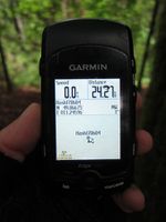
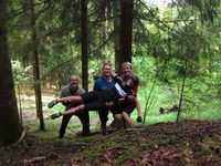
The small road from Aufseß to Draisendorf brought us at 150m distance and at a nearby forest road I left my bike and two of my friends. Surprisingly, the other three of them were already drunk enough to follow me uphill through the forest until I started my hashdance. My best photo was at 1m distance though - even the orienteering pro (ninja no. 2) couldn't get 0m, so we gave up on that and concentrated on more important things: I had no hashcot with me, so we'd have to take a picture of our stupid faces. And to prove we're absolute (albeit slightly drunk) self-timer pros the boys had the idea for the perfect proof picture - probably the very best Geohashing picture I'll ever get, yay!
Photos
|


