Difference between revisions of "2017-07-25 47 -122"
From Geohashing
imported>Thomcat ([live picture]Burke Gilman trail [http://www.openstreetmap.org/?lat=47.75804470&lon=-122.26113070&zoom=16&layers=B000FTF @47.7580,-122.2611]) |
imported>Thomcat (Success) |
||
| Line 18: | Line 18: | ||
== Expedition == | == Expedition == | ||
| − | + | Geohash point easily reached. Google maps shows it right next to a light pole, approximately on top of a fire hydrant (since removed). Actual scouting showed it a few meters east and slightly onto the street; I was able to get a reading of less than 2 meters without being run down by a commuter bus. | |
| + | |||
| + | Very willing to return later in the day and meetup with any other geohashers in the area. --[[User:Thomcat|Thomcat]] ([[User talk:Thomcat|talk]]) 16:02, 25 July 2017 (UTC) | ||
== Tracklog == | == Tracklog == | ||
| Line 42: | Line 44: | ||
<!-- Add any achievement ribbons you earned below, or remove this section --> | <!-- Add any achievement ribbons you earned below, or remove this section --> | ||
| − | |||
| − | |||
| − | |||
| − | |||
[[Category:Expeditions]] | [[Category:Expeditions]] | ||
[[Category:Expeditions with photos]] | [[Category:Expeditions with photos]] | ||
[[Category:Coordinates reached]] | [[Category:Coordinates reached]] | ||
| − | |||
| − | |||
| − | |||
| − | |||
| − | |||
| − | |||
| − | |||
| − | |||
| − | |||
| − | |||
| − | |||
Revision as of 16:02, 25 July 2017
| Tue 25 Jul 2017 in Seattle: 47.7582970, -122.2609161 geohashing.info google osm bing/os kml crox |
Location
Between highway 522 and the Burke Gilman trail; the sidewalk in front of a small building.
Participants
Plans
Initial scouting on the way to work; perhaps meet User:BenKaiser later in the day.
Expedition
Geohash point easily reached. Google maps shows it right next to a light pole, approximately on top of a fire hydrant (since removed). Actual scouting showed it a few meters east and slightly onto the street; I was able to get a reading of less than 2 meters without being run down by a commuter bus.
Very willing to return later in the day and meetup with any other geohashers in the area. --Thomcat (talk) 16:02, 25 July 2017 (UTC)
Tracklog
Photos
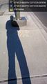
Mark and shadow @47.7583,-122.2610

Geohasher @47.7583,-122.2609
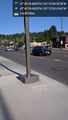
Location @47.7583,-122.2609
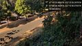
Burke Gilman trail @47.7580,-122.2611


