Difference between revisions of "2017-11-16 38 -122"
imported>Blueberrynewt (→Plans) |
imported>Fippe (coordinates reached) |
||
| Line 61: | Line 61: | ||
| name = Blueberrynewt | | name = Blueberrynewt | ||
}} | }} | ||
| − | |||
| − | |||
| − | |||
| − | |||
| − | |||
| − | |||
| − | |||
| − | |||
| − | |||
| − | |||
| − | |||
| − | |||
| − | |||
[[Category:Expeditions]] | [[Category:Expeditions]] | ||
| − | |||
[[Category:Expeditions with photos]] | [[Category:Expeditions with photos]] | ||
| − | |||
| − | |||
| − | |||
| − | |||
| − | |||
[[Category:Coordinates reached]] | [[Category:Coordinates reached]] | ||
| − | |||
| − | |||
| − | |||
| − | |||
| − | |||
| − | |||
| − | |||
| − | |||
| − | |||
| − | |||
| − | |||
| − | |||
| − | |||
| − | |||
| − | |||
| − | |||
| − | |||
| − | |||
Revision as of 15:25, 26 July 2019
| Thu 16 Nov 2017 in 38,-122: 38.2615651, -122.6427300 geohashing.info google osm bing/os kml crox |
Location
Northern Petaluma, just off of McDowell - on the side of a residential road called Woodside Circle.
Participants
Plans
I kind of made this one up as I went along, so no real plans existed until I was on my way to the hashpoint around 3. At that point, the plan went like this: get off the southbound 48x at Corona, bike up Corona and down McDowell and up Palo Verde and down Wood Sorrel, which turns into Woodside, which is where the point is. Afterwards, bike up to the Petaluma campus of the SRJC and catch the northbound 44 at 5:01. Unless I was super speedy, in which case bike all the way to Stonypoint to catch the 54 at 4:29.
Expedition
Everything went pretty much as planned. I managed to get off at the correct stop (which with me is not a guarantee), and found my way up Corona and over the freeway, etc. etc. Biking on McDowell is kind of stressful, especially when you manage to injure your ankle with a bike pedal... Hashpoint was among some roadside bushes, mud, and fallen leaves. I was there for a couple minutes total and wound up with mats of mud on both flip-flops that weighed several times what the shoes themselves weigh. A few people drove past while I was there and, as always, I wondered what they must think I was up to.
Once the point was documented, I struck out again on my bike, found my way to the JC, and caught the bus back.
Tracklog
Photos
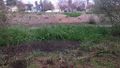
This is what the hashpoint looked like today, post-rain.
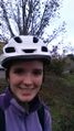
And this is what I looked like at the point, with a tree apparently growing out of my helmet.
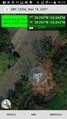
This is where I was when it told me I had made it (though not the closest I got).
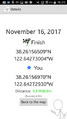
The closest reading I captured in a screenshot, though I got some lower ones as I stood there. 0.2, maybe?


Achievements
Blueberrynewt earned the Two to the N achievement
|