Difference between revisions of "2018-02-05 52 1"
From Geohashing
imported>Sourcerer m (Silly pic. [http://www.openstreetmap.org/?lat=52.17107892&lon=1.50544882&zoom=16&layers=B000FTF @52.1711,1.5054]) |
imported>Sourcerer m (→Added Image) |
||
| Line 21: | Line 21: | ||
== Expedition == | == Expedition == | ||
| + | *Arrived. -- [[User:Sourcerer|Sourcerer]] ([[User talk:Sourcerer|talk]]) [http://www.openstreetmap.org/?lat=52.17107892&lon=1.50544882&zoom=16&layers=B000FTF @52.1711,1.5054] 09:54, 5 February 2018 (GMT) | ||
| + | The journey out alternated between low blinding sun reflecting off the wet roads and heavy snow showers. There were multiple foot paths and road access to the hashpoint. My route was about 1km on foot after parking outside the village post office. The woodland path description was about right but there was also vehicle access at the hashpoint which was right in the middle of the path. | ||
| + | |||
| + | There's no explanation for the hat but it made me smile! | ||
| − | |||
== Photos == | == Photos == | ||
<gallery caption="Gallery" widths="200px" heights="200px" perrow="3"> | <gallery caption="Gallery" widths="200px" heights="200px" perrow="3"> | ||
| − | |||
Image:2018-02-05_52_1_Sourcerer_1517824409673.jpg | Proof. [http://www.openstreetmap.org/?lat=52.17107892&lon=1.50544882&zoom=16&layers=B000FTF @52.1711,1.5054] | Image:2018-02-05_52_1_Sourcerer_1517824409673.jpg | Proof. [http://www.openstreetmap.org/?lat=52.17107892&lon=1.50544882&zoom=16&layers=B000FTF @52.1711,1.5054] | ||
| − | |||
Image:2018-02-05_52_1_Sourcerer_1514211424000.jpg | Silly pic. [http://www.openstreetmap.org/?lat=52.17107892&lon=1.50544882&zoom=16&layers=B000FTF @52.1711,1.5054] | Image:2018-02-05_52_1_Sourcerer_1514211424000.jpg | Silly pic. [http://www.openstreetmap.org/?lat=52.17107892&lon=1.50544882&zoom=16&layers=B000FTF @52.1711,1.5054] | ||
| + | Image:2018-02-05_52_1_Sourcerer.jpg | Google Earth Track | ||
</gallery> | </gallery> | ||
| Line 42: | Line 44: | ||
}} | }} | ||
| − | [[Category: | + | [[Category:Expeditions]] |
[[Category:Expeditions with photos]] | [[Category:Expeditions with photos]] | ||
[[Category:Coordinates reached]] | [[Category:Coordinates reached]] | ||
Revision as of 15:40, 5 February 2018
| Mon 5 Feb 2018 in Norwich, UK: 52.1710395, 1.5054934 geohashing.info google osm bing/os kml crox |
Location
A woodland path at Snape, Suffolk, UK.
Participants
Plans
Just go ...
Expedition
- Arrived. -- Sourcerer (talk) @52.1711,1.5054 09:54, 5 February 2018 (GMT)
The journey out alternated between low blinding sun reflecting off the wet roads and heavy snow showers. There were multiple foot paths and road access to the hashpoint. My route was about 1km on foot after parking outside the village post office. The woodland path description was about right but there was also vehicle access at the hashpoint which was right in the middle of the path.
There's no explanation for the hat but it made me smile!
Photos
- Gallery
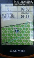
Proof. @52.1711,1.5054

Silly pic. @52.1711,1.5054
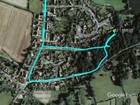
Google Earth Track


Achievements
Expeditions and Plans
| 2018-02-05 | ||
|---|---|---|
| Norwich, United Kingdom | Sourcerer | A woodland path at Snape, Suffolk, UK. |
Sourcerer's Expedition Links
2018-01-31 52 1 - 2018-02-05 52 1 - 2018-02-06 52 1 - KML file download of Sourcerer's expeditions for use with Google Earth.