Difference between revisions of "2018-04-23 47 -122"
From Geohashing
imported>Thomcat ([live picture]Maltby [http://www.openstreetmap.org/?lat=47.80512490&lon=-122.11466340&zoom=16&layers=B000FTF @47.8051,-122.1147]) |
imported>Thomcat (success and story) |
||
| Line 19: | Line 19: | ||
== Expedition == | == Expedition == | ||
<!-- how it all turned out. your narrative goes here. --> | <!-- how it all turned out. your narrative goes here. --> | ||
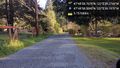
| + | Drove to work and past by a few kilometers. Turns out the road in question was marked "Private Road" and unpaved. That said, it shows on Google Maps and there was no gate. | ||
| + | |||
| + | Parked on the spot, snapped and uploaded, then turned around and snapped a picture of where I had been. Not much use in sidewalk chalk on gravel, so I left the private road and successful geohash. | ||
| + | |||
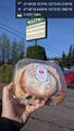
| + | The Maltby Cafe is between the hashpoint and where I work, so I stopped for a small treat. | ||
== Tracklog == | == Tracklog == | ||
| Line 40: | Line 45: | ||
<!-- Add any achievement ribbons you earned below, or remove this section --> | <!-- Add any achievement ribbons you earned below, or remove this section --> | ||
| − | |||
| − | |||
| − | |||
| − | |||
[[Category:Expeditions]] | [[Category:Expeditions]] | ||
[[Category:Expeditions with photos]] | [[Category:Expeditions with photos]] | ||
[[Category:Coordinates reached]] | [[Category:Coordinates reached]] | ||
| − | |||
| − | |||
| − | |||
| − | |||
| − | |||
| − | |||
| − | |||
| − | |||
| − | |||
| − | |||
| − | |||
Revision as of 16:24, 23 April 2018
| Mon 23 Apr 2018 in Seattle: 47.8329911, -122.0942430 geohashing.info google osm bing/os kml crox |
Location
Side of the road just north of Maltby.
Participants
Plans
Stop by before work, possibly snagging a Maltby cinnamon roll for breakfast.
Expedition
Drove to work and past by a few kilometers. Turns out the road in question was marked "Private Road" and unpaved. That said, it shows on Google Maps and there was no gate.
Parked on the spot, snapped and uploaded, then turned around and snapped a picture of where I had been. Not much use in sidewalk chalk on gravel, so I left the private road and successful geohash.
The Maltby Cafe is between the hashpoint and where I work, so I stopped for a small treat.
Tracklog
Photos

Geohasher @47.8330,-122.0942
South of point @47.8329,-122.0942
Maltby @47.8051,-122.1147


