Difference between revisions of "2018-08-11 51 9"
From Geohashing
imported>GeorgDerReisende (new report) |
imported>GeorgDerReisende (expedition report for Habichtswald-Dörnberg) |
||
| Line 1: | Line 1: | ||
| − | |||
| − | |||
| − | |||
| − | |||
| − | |||
| − | |||
| − | |||
| − | |||
| − | |||
| − | |||
{{meetup graticule | {{meetup graticule | ||
| lat=51 | | lat=51 | ||
| Line 19: | Line 9: | ||
== Location == | == Location == | ||
| − | + | ||
| + | The hash lay on a harvested field near Dörnberg. | ||
== Participants == | == Participants == | ||
| − | + | ||
| − | + | [[User:GeorgDerReisende|GeorgDerReisende]] | |
== Plans == | == Plans == | ||
| − | + | ||
| + | Taking the bus to Dörnberg and walking. | ||
== Expedition == | == Expedition == | ||
| − | |||
| − | + | I took the bus 110 to Dörnberg and walked to the hash. I found it on a harvested field. I walked around this field on the unsuccessful walk to [[2017-03-23 51 9]], but today it was easy to find. I waited some minutes for hash o'clock, took the usual photos and went away. | |
| − | |||
== Photos == | == Photos == | ||
| Line 39: | Line 29: | ||
--> | --> | ||
<gallery perrow="5"> | <gallery perrow="5"> | ||
| + | Image:2018-08-11 51 9 GeorgDerReisende 8994.jpg | at the rear end of this field, there was the hash | ||
| + | Image:2018-08-11 51 9 GeorgDerReisende 8995.jpg | this field is too rear | ||
| + | Image:2018-08-11 51 9 GeorgDerReisende 9004.jpg | ten meters ahead | ||
| + | Image:2018-08-11 51 9 GeorgDerReisende 9008.jpg | proof of dance | ||
| + | Image:2018-08-11 51 9 GeorgDerReisende 9010.jpg | proof of hash o'clock | ||
| + | Image:2018-08-11 51 9 GeorgDerReisende 9011.jpg | the north | ||
| + | Image:2018-08-11 51 9 GeorgDerReisende 9012.jpg | the east | ||
| + | Image:2018-08-11 51 9 GeorgDerReisende 9013.jpg | the south | ||
| + | Image:2018-08-11 51 9 GeorgDerReisende 9014.jpg | the west | ||
| + | Image:2018-08-11 51 9 GeorgDerReisende 9015.jpg | the geohasher | ||
</gallery> | </gallery> | ||
| Line 45: | Line 45: | ||
<!-- Add any achievement ribbons you earned below, or remove this section --> | <!-- Add any achievement ribbons you earned below, or remove this section --> | ||
| − | + | {{XKCD Centurion | count = 43 | name = GeorgDerReisende }} | |
| − | |||
| − | |||
| − | + | [[Category:Expeditions]] | |
| − | + | [[Category:Expeditions with photos]] | |
| − | |||
| − | [[Category: | ||
| − | |||
| − | |||
| − | |||
| − | |||
| − | |||
| − | |||
| − | |||
| − | |||
| − | |||
| − | |||
| − | |||
| − | |||
[[Category:Coordinates reached]] | [[Category:Coordinates reached]] | ||
| − | |||
| − | |||
| − | |||
| − | |||
| − | |||
| − | |||
| − | |||
| − | |||
| − | |||
| − | |||
| − | |||
| − | |||
| − | |||
| − | |||
| − | |||
| − | |||
| − | |||
| − | |||
Revision as of 06:31, 15 August 2018
| Sat 11 Aug 2018 in 51,9: 51.3385797, 9.3616675 geohashing.info google osm bing/os kml crox |
Location
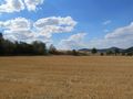
The hash lay on a harvested field near Dörnberg.
Participants
Plans
Taking the bus to Dörnberg and walking.
Expedition
I took the bus 110 to Dörnberg and walked to the hash. I found it on a harvested field. I walked around this field on the unsuccessful walk to 2017-03-23 51 9, but today it was easy to find. I waited some minutes for hash o'clock, took the usual photos and went away.
Photos
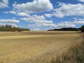
at the rear end of this field, there was the hash
this field is too rear
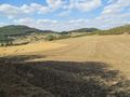
ten meters ahead
proof of dance
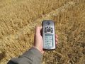
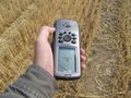
proof of hash o'clock
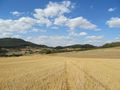
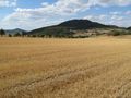
the north
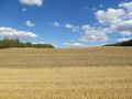
the east
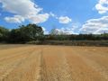
the south
the west
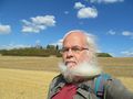
the geohasher


Achievements
GeorgDerReisende earned the xkcd Quadraginturion achievement
|