Difference between revisions of "2018-12-12 43 -79"
imported>Meggs413 (→Plans) |
imported>Meggs413 (→Achievements) |
||
| Line 55: | Line 55: | ||
<!-- Add any achievement ribbons you earned below, or remove this section --> | <!-- Add any achievement ribbons you earned below, or remove this section --> | ||
| − | + | {{land geohash | |
| − | + | | latitude = 43 | |
| − | + | | longitude = -79 | |
| + | | date = 2018-12-12 | ||
| + | | name = Meggs413 | ||
| + | }} | ||
| − | + | {{Golf geohash | |
| + | | latitude = 43 | ||
| + | | longitude = -79 | ||
| + | | date = 2018-12-12 | ||
| + | | name = Meggs413 | ||
| + | }} | ||
| − | + | {{Public transport geohash | |
| − | + | | latitude = 43 | |
| − | + | | longitude = -79 | |
| − | + | | date = 2018-12-12 | |
| + | | busline = TTC and YRT | ||
| + | | name = Meggs413 | ||
| + | }} | ||
| − | + | {{Frozen Geohash | |
| − | + | | latitude = 43 | |
| − | + | | longitude = -79 | |
| − | -- | + | | date = 2018-12-12 |
| − | + | | temperature = -3°C | |
| − | + | | name = Meggs413 | |
| − | + | }} | |
| − | |||
| − | |||
| − | |||
| − | |||
| + | {{Two to the N achievement | ||
| − | -- | + | | count = 0 |
| − | + | | date = 2018-12-12 | |
| − | - | + | | latitude = 43 |
| − | + | | longitude = -79 | |
| − | + | | name = Meggs413 | |
| − | + | | reached = true (optional - include if you are counting coordinates reached) | |
| − | |||
| − | |||
| − | + | }} | |
| − | |||
| − | |||
| − | |||
| − | |||
| − | + | [[Category:New report]] | |
| + | [[Category:Expeditions]] | ||
| + | [[Category:Expeditions with photos]] | ||
| + | [[Category:Coordinates reached]] | ||
Revision as of 05:19, 13 December 2018
| Wed 12 Dec 2018 in 43,-79: 43.8648960, -79.2447016 geohashing.info google osm bing/os kml crox |
Location
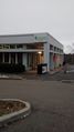
Near, or potentially in, a golf course in Markham.
Participants
Plans
Going to head up on the TTC, then walk the last stretch. Hopefully will not get stopped by the existence of a golf course. If the situation presents itself, I will definitely attempt to sink a golf ball.
Edit: How could I forget that golf closes in winter???
Expedition
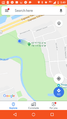
The trip started just west of Kipling station, with me taking the subway and 102D bus to Markham. I got off just north of the 407, in a beautiful little neighborhood that included several parkettes and cul de sacs. It was quite easy to access the park that contained the geohash, despite Google Maps insisting that there were no connecting roads or paths. After a short, uneventful walk, I reached the geohash.
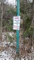
The geohash itself was in an area of snow and bramble just off the main path. Literally 5 meters west, there was a "No Trespassing" sign from the Markland Green golf course. I don't know whether to consider myself lucky for so narrowly missing the threat of prosecution, or unlucky for being only 5 METRES OFF from the golf green. I did cut through the course by accident on my way to the hash, so I'll consider it 'close enough'.
After taking some photos of the hash, my phone immediately died. I retained my "proof", but got embarrassingly lost without GPS. Thankfully, I stumbled upon a small church and was able to ask directions, getting to the bus stop just as it went completely dark outside. There was a massive sense of relief and accomplishment, naturally. Pretty darn nice for a first geohash!
Photos
I approach...
Hash Reached! Proof by Google Maps?

My truly stupid first-hash grin
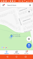
5m away from hashpoint...
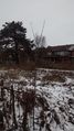
Photo from hashpoint. Looked nicer in person.

I'm just happy to be here!
Golf hash!!!!!
Closest I could get the site to register


Achievements
Meggs413 earned the Land geohash achievement
|
Meggs413 earned the Golf Geohash Achievement
|
Meggs413 earned the Public transport geohash achievement
|

