Difference between revisions of "2018-12-29 53 -1"
From Geohashing
imported>Sourcerer m ([live picture] HP [http://www.openstreetmap.org/?lat=53.14963460&lon=-1.17969453&zoom=16&layers=B000FTF @53.1496,-1.1797]) |
imported>Sourcerer m (→New expedition) |
||
| Line 1: | Line 1: | ||
| − | |||
| − | |||
| − | |||
| − | |||
| − | |||
| − | |||
| − | |||
| − | |||
| − | |||
| − | |||
{{meetup graticule | {{meetup graticule | ||
| lat=53 | | lat=53 | ||
| lon=-1 | | lon=-1 | ||
| date=2018-12-29 | | date=2018-12-29 | ||
| + | | graticule_name=Sheffield | ||
| + | | graticule_link=Sheffield, United Kingdom | ||
}} | }} | ||
| + | __NOTOC__ | ||
| + | == Location == | ||
| − | + | A patch of park land in Mansfield, Nottinghamshire, UK. | |
| − | + | ||
| + | == Planning == | ||
| − | + | Go early to dodge the holiday traffic. Visit the park. Return to Mike and Jane's house and spend the rest of the day eating and drinking! | |
| − | |||
== Participants == | == Participants == | ||
| − | |||
| − | |||
| − | + | * [[User:Sourcerer|Sourcerer]] | |
| − | |||
== Expedition == | == Expedition == | ||
| − | |||
| − | + | In mild bright slightly overcast weather, Sourcerer headed east to Mansfield. This is close to "Robin Hood" country and not far from Nottingham. Sadly I had not brought my green tights! There was a place to park and the hashpoint was on a grassy square near a village hall and community centre. | |
| − | |||
| − | |||
| − | |||
| − | |||
| − | |||
| − | |||
| − | |||
| + | == Photos == | ||
| + | <gallery caption="Gallery" widths="200px" heights="200px" perrow="3"> | ||
Image:2018-12-29_53_-1_Sourcerer_1546081384399.jpg | Proof [http://www.openstreetmap.org/?lat=53.14962387&lon=-1.17969453&zoom=16&layers=B000FTF @53.1496,-1.1797] | Image:2018-12-29_53_-1_Sourcerer_1546081384399.jpg | Proof [http://www.openstreetmap.org/?lat=53.14962387&lon=-1.17969453&zoom=16&layers=B000FTF @53.1496,-1.1797] | ||
| − | |||
Image:2018-12-29_53_-1_Sourcerer_1546081314928.jpg | HP [http://www.openstreetmap.org/?lat=53.14962924&lon=-1.17969990&zoom=16&layers=B000FTF @53.1496,-1.1797] | Image:2018-12-29_53_-1_Sourcerer_1546081314928.jpg | HP [http://www.openstreetmap.org/?lat=53.14962924&lon=-1.17969990&zoom=16&layers=B000FTF @53.1496,-1.1797] | ||
| − | |||
Image:2018-12-29_53_-1_Sourcerer_1546081330748.jpg | HP [http://www.openstreetmap.org/?lat=53.14963460&lon=-1.17969453&zoom=16&layers=B000FTF @53.1496,-1.1797] | Image:2018-12-29_53_-1_Sourcerer_1546081330748.jpg | HP [http://www.openstreetmap.org/?lat=53.14963460&lon=-1.17969453&zoom=16&layers=B000FTF @53.1496,-1.1797] | ||
| − | |||
Image:2018-12-29_53_-1_Sourcerer_1546081349661.jpg | HP [http://www.openstreetmap.org/?lat=53.14963460&lon=-1.17969453&zoom=16&layers=B000FTF @53.1496,-1.1797] | Image:2018-12-29_53_-1_Sourcerer_1546081349661.jpg | HP [http://www.openstreetmap.org/?lat=53.14963460&lon=-1.17969453&zoom=16&layers=B000FTF @53.1496,-1.1797] | ||
</gallery> | </gallery> | ||
== Achievements == | == Achievements == | ||
| − | |||
| − | |||
| − | + | {{Sourcerer_links | |
| − | + | | prev = 2018-12-28_53_-2 | |
| − | + | | curr = 2018-12-29_53_-1 | |
| − | + | | next = 2018-12-29_53_-2 | |
| − | + | | date = 2018-12-29 | |
| − | + | }} | |
| − | |||
| − | |||
| − | |||
| − | -- | ||
| − | |||
| − | |||
| − | |||
[[Category:Expeditions]] | [[Category:Expeditions]] | ||
| − | |||
[[Category:Expeditions with photos]] | [[Category:Expeditions with photos]] | ||
| − | |||
| − | |||
| − | |||
| − | |||
| − | |||
| − | |||
| − | |||
[[Category:Coordinates reached]] | [[Category:Coordinates reached]] | ||
| − | |||
| − | |||
| − | |||
| − | |||
| − | |||
| − | |||
| − | |||
| − | |||
| − | |||
| − | |||
| − | |||
| − | |||
| − | |||
| − | |||
| − | |||
| − | |||
| − | |||
| − | |||
Revision as of 14:52, 29 December 2018
| Sat 29 Dec 2018 in Sheffield: 53.1496433, -1.1796691 geohashing.info google osm bing/os kml crox |
Location
A patch of park land in Mansfield, Nottinghamshire, UK.
Planning
Go early to dodge the holiday traffic. Visit the park. Return to Mike and Jane's house and spend the rest of the day eating and drinking!
Participants
Expedition
In mild bright slightly overcast weather, Sourcerer headed east to Mansfield. This is close to "Robin Hood" country and not far from Nottingham. Sadly I had not brought my green tights! There was a place to park and the hashpoint was on a grassy square near a village hall and community centre.
Photos
- Gallery
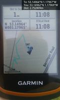
Proof @53.1496,-1.1797


Achievements
Expeditions and Plans
| 2018-12-29 | ||
|---|---|---|
| Sheffield, United Kingdom | Sourcerer | A patch of park land in Mansfield, Nottinghamshire, UK. |
| Manchester, United Kingdom | Sourcerer | Near the perimeter hedge of Congleton Golf Course, Cheshire East, UK. |
Sourcerer's Expedition Links
2018-12-28_53_-2 - 2018-12-29_53_-1 - 2018-12-29_53_-2 - KML file download of Sourcerer's expeditions for use with Google Earth.