Difference between revisions of "2019-03-16 45 -122"
imported>Michael5000 (Created page with "{{subst:Expedition |lat = 45 |lon = -122 |date = 2019-03-16 }}") |
imported>Michael5000 |
||
| Line 1: | Line 1: | ||
| − | |||
| − | |||
| − | |||
| − | |||
| − | |||
| − | |||
| − | |||
| − | |||
| − | |||
{{meetup graticule | {{meetup graticule | ||
| lat=45 | | lat=45 | ||
| Line 15: | Line 6: | ||
}} | }} | ||
| − | + | == Location == | |
| − | |||
| − | + | In a woods in the hills between Newberg and Wilsonville. | |
| − | |||
== Participants == | == Participants == | ||
| − | + | ||
| − | + | [[User:Michael5000:Michael5000]] | |
== Plans == | == Plans == | ||
| − | + | ||
| + | When I looked at the hashpoints on Friday, I thought (as one often does) "what a bunch of junk." Then, I drove down to Corvallis for an event on Saturday. When I started back, I looked at this hashpoint a little more carefully and thought, hmm, maybe it could be done... | ||
== Expedition == | == Expedition == | ||
| − | |||
| − | + | I got pretty close to the site via some narrow little country roads, and found a shoulder wide enough to pull off on. Then, it was all suspiciously easy: there was a trail up the hill, to an old long-abandoned road that got me closer to the hashpoint, then a little deer trail that brought me right to it. It was, you know, a spot in the woods. I took pictures, went back down to the car, and drove home. | |
| − | + | ||
== Photos == | == Photos == | ||
| − | |||
| − | |||
| − | |||
<gallery perrow="5"> | <gallery perrow="5"> | ||
| + | File:2019-03-16 45 -122 car.jpg|The car did most of the work, of course. | ||
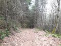
| + | File:2019-03-16 45 -122 trail.jpg|But this was a rather steep trail. | ||
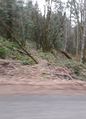
| + | File:2019-03-16 45 -122 road.jpg|Here's the abandoned road. | ||
| + | File:2019-03-16 45 -122 shovel.jpg|There's something mildly unsettling about finding a random shovel in the woods. Also, hard to photograph. | ||
| + | File:2019-03-16 45 -122 view.jpg|Here's what the hashpoint looked like. | ||
| + | File:2019-03-16 45 -122 me.jpg|Here's what I looked like. | ||
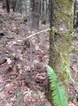
| + | File:2019-03-16 45 -122 thing.jpg|Here's a thing I noticed strapped to the tree. I don't know what it is. But perhaps as I photographed it, it also was photographing me? | ||
</gallery> | </gallery> | ||
| Line 45: | Line 38: | ||
<!-- Add any achievement ribbons you earned below, or remove this section --> | <!-- Add any achievement ribbons you earned below, or remove this section --> | ||
| − | |||
| − | |||
| − | |||
| − | |||
| − | |||
| − | |||
| − | |||
| − | |||
| − | |||
| − | |||
| − | |||
| − | |||
| − | |||
| − | |||
[[Category:Expeditions]] | [[Category:Expeditions]] | ||
| − | |||
[[Category:Expeditions with photos]] | [[Category:Expeditions with photos]] | ||
| − | |||
| − | |||
| − | |||
| − | |||
| − | |||
| − | |||
| − | |||
[[Category:Coordinates reached]] | [[Category:Coordinates reached]] | ||
| − | |||
| − | |||
| − | |||
| − | |||
| − | |||
| − | |||
| − | |||
| − | |||
| − | |||
| − | |||
| − | |||
| − | |||
| − | |||
| − | |||
| − | |||
| − | |||
| − | |||
| − | |||
Revision as of 03:34, 17 March 2019
| Sat 16 Mar 2019 in 45,-122: 45.3138814, -122.8637556 geohashing.info google osm bing/os kml crox |
Location
In a woods in the hills between Newberg and Wilsonville.
Participants
Plans
When I looked at the hashpoints on Friday, I thought (as one often does) "what a bunch of junk." Then, I drove down to Corvallis for an event on Saturday. When I started back, I looked at this hashpoint a little more carefully and thought, hmm, maybe it could be done...
Expedition
I got pretty close to the site via some narrow little country roads, and found a shoulder wide enough to pull off on. Then, it was all suspiciously easy: there was a trail up the hill, to an old long-abandoned road that got me closer to the hashpoint, then a little deer trail that brought me right to it. It was, you know, a spot in the woods. I took pictures, went back down to the car, and drove home.
Photos
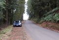
The car did most of the work, of course.
But this was a rather steep trail.
Here's the abandoned road.
There's something mildly unsettling about finding a random shovel in the woods. Also, hard to photograph.
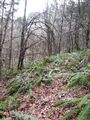
Here's what the hashpoint looked like.
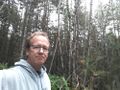
Here's what I looked like.
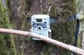
Here's a thing I noticed strapped to the tree. I don't know what it is. But perhaps as I photographed it, it also was photographing me?


