Difference between revisions of "2019-07-14 47 9"
From Geohashing
imported>Fippe (Location: Condominium per http://www.bodensee-geodatenpool.net/Bodensee/images/Publikationen/Karte%203%20-%20Staatsgebiete.pdf) |
imported>Fippe (coordinates reached) |
||
| Line 1: | Line 1: | ||
| − | |||
| − | |||
| − | |||
| − | |||
| − | |||
| − | |||
| − | |||
| − | |||
| − | |||
| − | |||
{{meetup graticule | {{meetup graticule | ||
| lat=47 | | lat=47 | ||
| Line 14: | Line 4: | ||
| date=2019-07-14 | | date=2019-07-14 | ||
}} | }} | ||
| − | |||
| − | |||
| − | |||
== Location == | == Location == | ||
| − | + | In the water of [[wikipedia:Lake Constance|Lake Constance]], 1.5km away from the shore of [[wikipedia:Immenstaad am Bodensee|Schloss Kirchberg]]. | |
== Participants == | == Participants == | ||
| − | + | *[[User:RecentlyChanged|RecentlyChanged]] | |
| − | + | *a drag-along | |
| − | |||
| − | |||
| − | |||
== Expedition == | == Expedition == | ||
| − | + | The pictures show that this expedition was successful. Judging by the reflection in their sunglasses the geohashers went on a motorboat and reached the spot. | |
| − | |||
| − | |||
| − | |||
== Photos == | == Photos == | ||
| − | |||
| − | |||
| − | |||
<gallery perrow="5"> | <gallery perrow="5"> | ||
| − | |||
Image:2019-07-14_47_9_RecentlyChanged_1563108947922.jpg|Stupid grin [http://www.openstreetmap.org/?lat=47.65728550&lon=9.31779140&zoom=16&layers=B000FTF @47.6573,9.3178] | Image:2019-07-14_47_9_RecentlyChanged_1563108947922.jpg|Stupid grin [http://www.openstreetmap.org/?lat=47.65728550&lon=9.31779140&zoom=16&layers=B000FTF @47.6573,9.3178] | ||
| Line 47: | Line 24: | ||
== Achievements == | == Achievements == | ||
{{#vardefine:ribbonwidth|800px}} | {{#vardefine:ribbonwidth|800px}} | ||
| − | + | {{water geohash | latitude = 47 | longitude = 9 | date = 2019-07-14 | name = RecentlyChanged + drag-along}} | |
| + | {{drag-along | latitude = 47 | longitude = 9 | date = 2019-07-14 | name = RecentlyChanged | partner = someone}} | ||
| − | + | __NOTOC__ | |
| − | |||
| − | |||
| − | |||
| − | |||
| − | |||
| − | |||
| − | |||
| − | |||
| − | |||
| − | |||
| − | |||
| − | |||
| − | |||
[[Category:Expeditions]] | [[Category:Expeditions]] | ||
| − | |||
[[Category:Expeditions with photos]] | [[Category:Expeditions with photos]] | ||
| − | |||
| − | |||
| − | |||
| − | |||
| − | |||
[[Category:Coordinates reached]] | [[Category:Coordinates reached]] | ||
| − | |||
| − | |||
| − | |||
| − | |||
| − | |||
| − | |||
| − | |||
| − | |||
| − | |||
| − | |||
| − | |||
| − | |||
| − | |||
| − | |||
| − | |||
| − | |||
| − | |||
| − | |||
{{location|AT|V}} | {{location|AT|V}} | ||
{{location|DE|BW}} | {{location|DE|BW}} | ||
Revision as of 17:38, 16 August 2019
| Sun 14 Jul 2019 in 47,9: 47.6573746, 9.3178147 geohashing.info google osm bing/os kml crox |
Location
In the water of Lake Constance, 1.5km away from the shore of Schloss Kirchberg.
Participants
- RecentlyChanged
- a drag-along
Expedition
The pictures show that this expedition was successful. Judging by the reflection in their sunglasses the geohashers went on a motorboat and reached the spot.
Photos
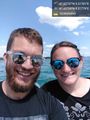
Stupid grin @47.6573,9.3178
Proof @47.6573,9.3178


Achievements
RecentlyChanged + drag-along earned the Water geohash achievement
|
RecentlyChanged earned the Drag-along achievement
|