Difference between revisions of "2019-08-11 45 -120"
imported>Michael5000 m (→Participants) |
imported>Michael5000 |
||
| Line 27: | Line 27: | ||
== Plans == | == Plans == | ||
| − | + | ||
| + | This hashpoint was just off of one of the most spectacular easy-to-access trails in Oregon. If I was in full running trim, it would have been a complete no-brainer. As it was, it was very tempting -- and after waking up Sunday, I went for it! | ||
== Expedition == | == Expedition == | ||
| − | |||
| − | + | First, there was a hundred miles of interstate driving east through the always spectacular Columbia Gorge. | |
| − | + | ||
| + | There is a state park where the Deschutes River reaches its confluence with the Columbia, and there is a blessedly free parking lot off the entrance for access to the trail running up the canyon. The trail follows an old railroad grade -- the history of which I will spare you the long-winded story of -- and it therefore wide and at a consistent, even grade. I ran two miles up it, which is my current limit, then walked back to a side path that led down to within a short trudge through sagebrush of the hashpoint. | ||
| + | |||
| + | After that, I climbed back up to the trail, walked back to the car, and got my bike out. I rode the bike five miles up the canyon... and then, of course, rode it five miles back. Then I went on a little drive through Sherman and Wasco Counties, and then I went home, had dinner, and did the Sunday puzzle with Mrs.5000. Pretty good Sunday, really. | ||
== Photos == | == Photos == | ||
| − | |||
| − | |||
| − | |||
<gallery perrow="5"> | <gallery perrow="5"> | ||
| + | File:2019-08-11 45 -120 trail 1.jpg|The trail up the canyon. | ||
| + | File:2019-08-11 45 -120 trail.jpg|The side trail down to the hashpoint area. | ||
| + | File:2019-08-11 45 -120 there.jpg|Ta da! | ||
| + | File:2019-08-11 45 -120 me.jpg|Yay, me! | ||
| + | File:2019-08-11 45 -120 view.jpg|View down to the Deschutes from the hashpoint. | ||
</gallery> | </gallery> | ||
| Line 46: | Line 51: | ||
<!-- Add any achievement ribbons you earned below, or remove this section --> | <!-- Add any achievement ribbons you earned below, or remove this section --> | ||
| − | + | *This is the first successful Expedition to Sherman County, I'm pretty sure. | |
| − | + | *My 33rd of 36 Oregon Counties attempted, my 30th succeeded in. | |
| − | + | *[[Goldendale, Washington|Goldendale]] becomes my fourth most-attempted graticule! | |
| − | |||
| − | |||
| − | |||
| − | |||
| − | |||
| − | [[ | ||
| − | |||
| − | |||
| − | |||
| − | |||
[[Category:Expeditions]] | [[Category:Expeditions]] | ||
| − | |||
[[Category:Expeditions with photos]] | [[Category:Expeditions with photos]] | ||
| − | |||
| − | |||
| − | |||
| − | |||
| − | |||
[[Category:Coordinates reached]] | [[Category:Coordinates reached]] | ||
| − | |||
| − | |||
| − | |||
| − | |||
| − | |||
| − | |||
| − | |||
| − | |||
| − | |||
| − | |||
| − | |||
| − | |||
| − | |||
| − | |||
| − | |||
| − | |||
| − | |||
| − | |||
Revision as of 03:58, 12 August 2019
| Sun 11 Aug 2019 in 45,-120: 45.6273230, -120.9064326 geohashing.info google osm bing/os kml crox |
Location
Near the mouth of the Deschutes River.
Participants
- Michael5000 -- Expedition #224.
Plans
This hashpoint was just off of one of the most spectacular easy-to-access trails in Oregon. If I was in full running trim, it would have been a complete no-brainer. As it was, it was very tempting -- and after waking up Sunday, I went for it!
Expedition
First, there was a hundred miles of interstate driving east through the always spectacular Columbia Gorge.
There is a state park where the Deschutes River reaches its confluence with the Columbia, and there is a blessedly free parking lot off the entrance for access to the trail running up the canyon. The trail follows an old railroad grade -- the history of which I will spare you the long-winded story of -- and it therefore wide and at a consistent, even grade. I ran two miles up it, which is my current limit, then walked back to a side path that led down to within a short trudge through sagebrush of the hashpoint.
After that, I climbed back up to the trail, walked back to the car, and got my bike out. I rode the bike five miles up the canyon... and then, of course, rode it five miles back. Then I went on a little drive through Sherman and Wasco Counties, and then I went home, had dinner, and did the Sunday puzzle with Mrs.5000. Pretty good Sunday, really.
Photos
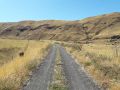
The trail up the canyon.
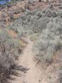
The side trail down to the hashpoint area.
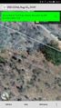
Ta da!
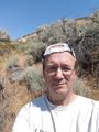
Yay, me!
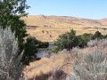
View down to the Deschutes from the hashpoint.


Achievements
- This is the first successful Expedition to Sherman County, I'm pretty sure.
- My 33rd of 36 Oregon Counties attempted, my 30th succeeded in.
- Goldendale becomes my fourth most-attempted graticule!