Difference between revisions of "North Cascades National Park, Washington"
From Geohashing
imported>AeroIllini (→Geohashes Attempted) |
imported>AeroIllini |
||
| Line 20: | Line 20: | ||
== Geohashes Attempted== | == Geohashes Attempted== | ||
| − | *[[2010-08-21 48 -121|2010-08-21]] -- Off a forestry road in Snoqualmie National Forest, near Echo Lake | + | *[[2010-08-21 48 -121|2010-08-21]] -- Off a forestry road in Snoqualmie National Forest, near Echo Lake Failed: no public access. |
*[[2009-06-18 48 -121|2009-06-18]] -- Just northeast of Darrington. | *[[2009-06-18 48 -121|2009-06-18]] -- Just northeast of Darrington. | ||
*[[2009-04-17 48 -121|2009-04-17]] -- Off a forestry road by a campground north of Darrington. '''Success!''' | *[[2009-04-17 48 -121|2009-04-17]] -- Off a forestry road by a campground north of Darrington. '''Success!''' | ||
Revision as of 01:46, 22 August 2010
Today's Location: [North Cascades National Park]
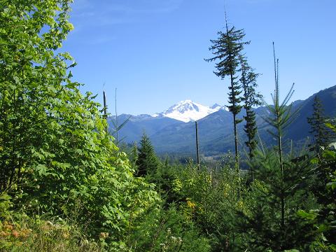
Mount Baker figures prominently in this mostly mountainous region. The National Park takes up a little less than one third of this graticule, which also contains towns of Darrington and Granite Falls. It is only crossed by one road, the North Cascades Highway.
Geohashes Attempted
- 2010-08-21 -- Off a forestry road in Snoqualmie National Forest, near Echo Lake Failed: no public access.
- 2009-06-18 -- Just northeast of Darrington.
- 2009-04-17 -- Off a forestry road by a campground north of Darrington. Success!
- 2008-09-13 -- Off a forestry service road near Maple Falls. Failed: too steep.
- 2008-07-19 -- Just off the Mountain Loop Highway, near Granite Falls. Failed: private property.
- 2008-06-25 -- Failed due to too much snow.
Local Geohashers
None yet!
