2009-04-17 48 -121
| Fri 17 Apr 2009 in North Cascades, WA: 48.3262266, -121.5006527 geohashing.info google osm bing/os kml crox |
Contents
[hide]Location
This day's geohash for North Cascades National Park, Washington fell about 13 km northeast of the town of Darrington, Washington, between the Sauk River, in undeveloped, wooded land just west of Mt Baker National Forest.
True But Misleading Facts About the Expedition
- Robyn's low fuel indicator illuminated and Robyn did not make it to the next town on the remaining fuel.
- Robyn spent most of the expedition in an area where her cell phone displayed an Emergency Service Only message.
- When Robyn returned to the GPS coordinates where she had left her car, there was a burned out car carcass at the site.
- Robyn called 911 and asked for the police
Planning
Robyn went geohashing yesterday and has a multihash planned for tomorrow, so she wasn't really intending to geohash today. She was just clicking around to see what other people were doing. For example, it looked like Thomcat was planning to going to North Cascades on Saturday. Rats, Robyn wanted to be there for that, but you can't be everywhere. Robyn started clicking around to see if there was somewhere she could go on Sunday. The peeron app covers up the map scale with some links so she had to keep clicking back and forth to Google Maps to see how far things were. When she reloaded the peeron app the date reset to the 17th, and at first she didn't notice. What she did notice is that today's location in the North Cascades was pretty close to a road. Hmmm. And the terrain wasn't too high, so it probably wasn't snowbound. Hmmm. It was already one-thirty. And it was 218 km away.
Robyn printed out directions, filled her water bottle, packed spare GPS batteries, thought about (but completely failed to find a way of) finding out if the back roads were open, grabbed T-Rex and called herself prepared.
Expedition (Robyn)
To the border
On the way to the border, I ate a package of salty snacks, which would have to pass for lunch, because there wasn't time to have any more and be assured of making the geohash in daylight. They were yummy dill-flavoured Crispers. Having finished the package, I reached for the water bottle. Aargh. It was still in the kitchen. I wouldn't mention such a trivial detail except that it's the third geohash in a row that I have not remembered to bring my water bottle. I'll have to endure a little thirst in the name of geohashing.
On highway 91 I was following an eighteen-wheeler transport truck, when suddenly it swerved, wobbling from one lane to another. It was just going under an overpass. I wondered if it had struck the overpass or had a tire blow, and then I saw what had happened. There was a mangled aluminum extension ladder lying in the lane the truck had been in. It was bouncing, and flicking up like a rake as vehicles hit it. I pulled out my cellphone, called 911, the Canadian emergency services number, and asked for the police. They listened to my description of the problem and location, and promised to send someone to look after it. I don't think that is in keeping with the spirit of the Police Geohash, so I won't try to claim it.
I passed the Saturday location in this graticule and tried to scope it out, knowing I'd be back there in less than twenty-four hours, trying to reach it. It looked as if there was quite a wide grassy area before the roadside ditch, so it would probably be attainable. It took me less half an hour to reach the border by car. Cars are so fast, it's amazing. I drove up to the immigration booth and answered the questions.
"Where are you going?"
"Just north of Darrington, in the North Cascades park."
"What is the purpose of your visit?"
"I heard that a friend of mine was going there, to go hiking. I'm going to surprise him. He doesn't know I'm coming." That's just as true as the true facts at the top of this expedition, but as you can see from the way the 911 story actually happened, true can still be misleading. In this case the border guard assumed that I was a normal person and was going to surprise Thomcat by meeting him there. I wish, and I would have sincerely tried that if I could be in two places at one. But in this case I was going to surprise Thomcat by sniping this virgin graticule right out from under his nose. You were surprised, right, Thomcat? I was permitted to pass through the border and I was soon zipping down I-5, looking for exit 208. I needed to buy gas, but decided I'd do that when I exited the I-5. No need to leave the highway more than I had to.
To the bottom of the gas tank

Exit 208 appeared about 110 km later, as scheduled, and I took it, following some complicated directions through Arlington to remain on Washington state highway 530. It wasn't until I was safely established going out of town that I remembered the bit about planning to refuel. Ah never mind. One bar on the gauge should be enough to get me to the next town, right? It's about 45 kilometres. I should be okay. And then there's a gas station right there., I signal, pull off and park in front of the pumps. There's a Winnebago parked on the other side. I get out my credit card, and then I notice that the gas pump has no digital numbers on it. And the store beyond the pumps is empty. And there are no prices on the Shell sign. D'oh. This is an abandoned gas station. I pull out back onto highway 530, the low fuel light flashing.
Okay, forty kilometres to Darrington. I can go forty kilometres on the remaining fuel, right? I drive at 80 km/h, what I believe to be the speed for best fuel economy in this car, and coincidentally pretty close to the local 50 mph speed limit. I will make it. I'm not heavily loaded, just me in the car. And then the road starts going uphill.
Now you'd think I'd have counted on some uphill driving, going as I am from a coastal graticule to a mountain one and well yeah, I was aware of that, but don't really like that it took this moment to start climbing. I can't drive thirty-nine kilometres uphill on the remaining fuel. Fortunately the area is populated, with houses all along the route, so I won't have to go far to beg for a quart of gasoline to get me to the next town. (They use quarts here. They're like small litres). I'm watching the low fuel light flash. It's a lousy gauge and doesn't really tell me how much is left, but I'm used to knowing what proportion of the tank capacity I put in for a fill after how many kilometres. I don't think I've ever driven this many kilometres on one tank before. I'm not going to make it to Darrington. Better to stop and ask for gasoline before the engine actually quits. I'm looking for someone who looks home and friendly.
Or how about here? There's a gas station ten miles outside of Darrington. The engine doesn't quit until I turn off the ignition with the key. I put eleven gallons of gas in a 40 L tank. Nice trick. I continue eastwards with that stress removed.
To the end of the road

I-530, or at least my association with it, ended at Darrington, and the Google Maps directions included a rapid succession of lefts and rights. I saw many of the road names that matched Google directions, but not the one I was supposed to turn on first. In the end I just drove straight through town to a T-intersection and left there, but still hooked up with the intended Sauk Prairie Road. I'm thinking, "isn't Sauk a kind of desert well, or a guy who drives a camel, or something?" In this case it's a river, which I cross on a traditional box bridge.
It's raining. I would say that it rains 24 hours a day in the Cascade Mountains, but I know for sure that it doesn't, because I've been here in the past when it was just starting to rain, and I also know it snows here. So it is only raining almost all the time here. The trees are all covered with moss. The road still has remarkably good pavement and no signs of snow. There's even other traffic around. I feel like I'm way out in the middle of nowhere, but I think some of these people are just coming home from work. Of course, as I'm there, I think maybe they are geohashing. I even put T-Rex on the dashboard so they will know it's me. Because I'm so famous everyone recognizes T-Rex, right?
There should be a turn soon. The car in front of me slows down. He's looking for the turn too, I surmise. He's a geohasher too. My mouth is dry with anticipation. No wait, my mouth is just dry, from eating those salty snacks then driving over two hours without my water bottle. But this is exciting.
The "other geohasher" turns off into a driveway. I find my left turn. There are no longer farms here. The road loops around and meets other roads, some named and some not, and some with names similar to those depicted on Google Maps. I choose some that I like and then the pavement ends and is replaced with gravel, which is replaced with mud. There are many potholes, all filled with water, and in some cases there is a chunk of road washed away. I ford a rivulet of overflowing ditchwater. I drive across some felled boughs and hear some scraping that reminds me that cars like this one don't have a lot of clearance under the spoilers or the transmission. I drive slowly so as not to become completely covered in mud and because I like my suspension. I also like suspense. The GPS is counting down in a most encouraging way.
I reach another fork in the road, which has long since ceased resemblance to Google Maps. The left fork becomes very narrow and not level enough for me to want to drive it. The right fork is also narrow and goes up a steep hill. I elect to drive through the fork to the left, then immediately reverse into the right fork, so that I have turned around and am now facing in the right direction to return home. I'm five hundred metres from the geohash and it would be cheating for me not to walk the rest of the way.
To the geohash

I left the car parked by the fork and chose to walk up the steep right fork. My logic was that as the direction needle showed its actual location to be somewhere between the two, it was easier to walk down to it than up to it when I had to leave the trail. As I walked uphill the GPS needle soon pointed abeam into the woods, and then distance to destination started increasing, but I kept to the road and was rewarded when it curved around somewhat towards the geohash again. Then, before reaching it, it ended at a rather surprising local maximum of terrain. It was a flat open area, kind of a gravel pit, with head height or higher earthen walls all around, as if the top of the hill had been scooped off. It was a bit like being on top of the lava plug inside a dormant volcano, if the walls of the surrounding crater were made of soft dirt instead of hard rock. I was on the edge of Mt. Baker (which is an active volcano) National Park, so perhaps this presumably non-volcanic hilltop had been sacrificed to surface roads leading into the volcanic one. It was an oddly industrial setting to find at the top of a road in a rainforest.
The geohash was now to my left, outside the rim of my metaphoric volcano. I climbed up the earth wall and looked down. It was very steep, very wet, mainly light deciduous trees and very deep mush with wet leaves on top. I take a couple of steps down. It would have been a treacherously steep slope had it been rock, but with the mush of soggy leaves and humus underfoot, my boot heels sink in for good footholds. With a stupidity distance of 130 metres I descend into the forest. It's still raining and everything is wet. I may be a candidate for the drowned rat geohash by the time this is over, but the straight-through-the-trees route is surprisingly easy going.
The forest isn't that thick, because the area has been logged over in the past. The deciduous cover is a clue there. I realize that there is so much rain here that everything that falls down or over rots into forest floor mush before it can accumulate into an impassibly tangled mess like Slave Lake, where there is much less rain, and much of the year things aren't rotting because they are frozen. As I near the bottom of the slope one of the laws of geohashing "There is always an easier way than the one you chose" comes into play, because there's a little road, or perhaps more accurately a trail about the width of my car, there. I figure it out: at the point where the road forked, the geohash appeared to be right of the left fork and left of the right fork, but the left fork must have immediately curved so far right around my hill, that the geohash is actually downhill from it, too.
It's only a little ways further downhill and I come out in a flat forested area, still quite open and passable. There are some very rotted, moss-covered logs on the ground, but they are easily stepped over and in some cases look like someone might have one chopped a path through the middle. I have the "someone else could have come here" feeling so strongly that when I reach the geohash site I make sure to photograph the time as well as the loation on the GPS and then look around carefully at the fallen branches, trying to read "xkcd" out of their placement. There are a lot that say x and k, but nothing I can believe is a c or d someone made. I make my own xckd marker out of those same branches, but I don't want to get any more rain on my non-waterproof camera than I have to, so I don't get it out again to photograph them.
Home

I head back the way I came and encounter what looks like a ditch. I didn't have to cross one on the way in, so I look back at the GPS trail to see how far I have to go left or right to get around the ditch, and am shocked to see that the GPS says I have walked further into the woods from the geohash, and not headed back the way I came. I know how easy it is to get turned around in the woods, but whoa, I'm 130 metres from the top of the hill. I can see the land sloping up on the other side of the ditch. How on earth did I get that disoriented? I turn back towards the geohash and then the GPS says I'm going in an entirely new direction. Oh. Forest cover, slope and GPS reception. The GPS is getting confused. I reach for my compass to resolve the ambiguity. My compass is in the car. So, come to think of it, are my spare GPS batteries. There are some batteries in my coat pocket, but I suspect they are dead ones. And I think there are aso some by-now-useless non-waterproof matches in that pocket. I have T-Rex and the GPS: that's all I brought.
T-Rex says I was going the right way to begin with, and I believe him. The ditch is really just a puddle and I go around it, back up the bank to the little sort-of road. Ordinarily I would have followed that road out, expecting that it would hook up with the not-taken fork, but I'm spooked enough by the fact that the GPS almost tricked me that I go straight up the bank again. Easy climbing, with the humus making as good footholds for my toes on the way up as it did for my heels on the way down. I'm soon climbing back over the lip of the gravel crater to the road that returns to the car.
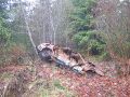
And at the bottom of the road is a car. The smashed and rusted out remains of a car. Oh no, I've gone through some sort of time portal, forward in time while my car sat here and was destroyed by the passage of time. So was my geohash even on the right day? Oh wait. My car is over there. Just the way I left it, only wetter. Phew. That rusted out car must have been there all along and I didn't notice it.
And then I reversed the whole expedition and was back home in under three hours.
Photographs
Sorry about the blurriness. I think for a time I had water on the autofocus aperture.
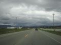
On highway 530 approaching the area of perpetual rain,
where the trees are all covered in moss.
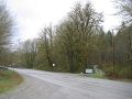
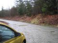
The paved surface ends
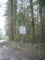
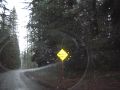
And there's a warning sign to tell me there are no warning signs
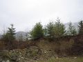
I go over this earth wall and down a hill

to the geohash.
And then return to the car.
Oops, this car.


Robyn earned the Graticule Unlocked Achievement
|