2008-08-24 55 -114
| Sun 24 Aug 2008 in 55,-114: 55.2739382, -114.5345287 geohashing.info google osm bing/os kml crox |
This geohash is 21 km outside of this graticule's namesake town, in fact only about 6 km further down the road that yielded the first successful Slave Lake conquest. It's accessible via a square site on the dead end of a dirt road, probably a utility substation of some sort. The actual point falls perhaps 70 m from the dirt, in what the satellite image shows as an irregularly-shaped black patch, a patch which I suspect is either swamp or open water. I could luck out and have it be an open excavation. That would be good because in the time since the picture was taken the excavation would have been backfilled, but thick vegetation would not yet have had time to regrow.
Contents
[hide]Planning
I have the day off tomorrow, so can start early in the morning, and I know how to get there, so the first 20.9 km it should be pretty straightforward. I'll have to decide whether to manufacture a raft in situ or bring something that can float, in case my suspicions about the black patch are founded.
And then what shall I do with the rest of the day? I'm thinking I'll head over to Utikuma Lake for a (first ever?) bicycle multihash!
Stupidly wild ambition never hurt anyone. The sun doesn't set until ten. And I have Monday off, too.
Participants
Expedition
I meant to leave at six, but was distracted by a sudden need to determine how many graticules were required to complete a Regional Geohash in British Columbia. I made a mess of my user page, and then did something else for a while, and finally got on the road at 8:30. I should still be back in Slave Lake before noon, with time to go and do phase two of the expedition.
Access Point #1
The first part of the trip went exactly as planned, along highway 2. Progress was slow, although I wasn't sure how much to blame on ICWB and how much on the headwind until a highway construction worker waved and commented on how windy it was. I reached the first turn-off in less than half an hour and that road continued straight through the Slave Lake industrial district with an OSB plant, an oil refinery, a pulp mill and maybe a plywood plant, I forget them all. After that the road continued straight, but turned to dirt. I expected my left turn in less than fifteen minutes, at about 9:15. I turned on the GPS and put it back in my backpack, so it would be on and tracking when I found the turn. But I didn't find it.
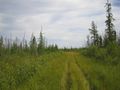
The satellite view shows a sideroad that goes north to a square area, then forks into a Y with another unnaturally square area at the end of each fork. On the way I even had fantasies about the east one being a dock, with boats and people to take my picture as I attempted the water hash. But there was no road. Now if Google Maps shows an open field, and you go there and find a mall, that's just civilization doing what it does. But could the forest swallow up a road that quickly, even if its purpose were gone? Did I misclick in the application that gives me the lat-long of intersections? I ride back and forth along the road a few times, looking for the invisible road.
I notice that there is a gap in the trees at one point, about road width, and wonder if the road once went through there. How old are those Google Maps images, anyway? A place where there one was a road will certainly be easier to walk than one where there has never been one, so I try it. At first it goes pretty well, and I can even see the marks in the grass where someone else has been here. Another geohasher in Slave Lake?! How exciting. But my trail ends in a moose bed, a hollow in the grass where an animal slept. It's not just humans that make trails in the grass. Then the going becomes much harder. I'm now walking in a swamp that has been covered over by small bore fallen trees which in turn have been covered over by grasses. It's an obstacle course. I turn my ankle a couple of times and almost fall into murky sinkholes. I climb up on a stump and look around for any better route. Most of the way ahead of me is open murky pondwater, with swamp either side. This is not a road. I am 0.44 from the geohash, but I don't go that way. I turn for home, stopping to find a geocache (success!) right on the route.
Access Point #2
Even though the road I had been on went right through the GPS mark where the coordinates were supposed to be, I still wondered if that were the right access road. And if one could disappear, another could appear. I looked at the map of the area I've slowly being building up through geohashing, and there was another going in the right direction. Maybe it goes closer than it shows. Plus the point of riding 60 km to the next hashpoint was to get the multihash achievement, and I can't do that if I don't get this one. So I'd better get this one.
I take a gnarly gravel road that ends at a loudly thumping oil pump. I park ICWB there, taking advantage of its one redeeming feature, a kickstand, and continue on foot through a meadow. It's very easy going, level footing, quite short grass, and it's already been tracked through by a quad. I follow it for a couple of kilometres. The track in the meadow stops going towards the geohash when I'm 0.65 nm away, so I turn and walk through a different part of the meadow, still grassy, but with saplings growing, not quite as high as the grass yet.
The meadow ends at a stand of dead-looking conifer trees. On closer inspection they are dead, killed in a forest fire. Each one is about the diameter of a water bottle, for various sizes of water bottles. Some are charred black posts. Others still have a little tuft of needles at the very top, but are nothing but dead sticks below. Many have fallen over and pile on top of each other, making a spiky-branched jungle gym. The forest floor is fairly solid, though. There is firm footing, with some tough springy ground cover, and blueberries, lots of ripe blueberries. Once again I eat berries and do not photograph them. I'm sorry, but the impulse "see berries -> eat berries" is far more ancient and has faster access to the nervous system than the impulse "see berries -> photograph berries." I climb over, under and between trees, until the underfoot layer changes. It has become a little swampy. Well what would a Slave Lake geohash be without a swamp? In another however many years it takes it to happen, this will be as bad as the other end, but right now it's traversable. And there's an animal trail to follow, too. As I squeeze between trees, getting charcoal on my arms and legs I suddenly realize that I am quite literally traversing the fireswamp. I see no ROUSes, though. Only a small frog.
The trees end and my animal trail continues around the edge of a startlingly beautiful pond. Look at the picture and realize that I'm not on any kind of road or path, just following the footsteps of what was probably a moose. The thick marsh grass is all around me and I'm just here in the middle of nowhere. The problem with following a moose is that moose don't wear socks. Or at least if they do, they don't mind getting them wet. I do and I do. I find the best way to move in the marsh is to sweep my foot from the side to the front, laying down a swathe of marsh grass to step on, then quickly doing it again with the other foot. You won't sink in if you keep moving. On the other side of the marsh is another stand of burned trees, but the footing is different, more squishy. The trees compensate by being a little further apart here. It's now 12:15 and I've covered about half the distance from the meadow to the hashpoint, at a rate of about 0.01 nm per minute. So, another half hour or so.
The burned trees end and I get open ground with little Christmas-tree sized conifers The geohash is 0.15 nm away. That's about 300 m. I tell myself I can probably see it from here. I was telling myself wrong, though, because the last 0.10 is inside a forest just like the one that left me MNB. That's what the extra dark patch was: impenetrable forest. But a tenth of a mile I can do. Even though this forest has way more bloodsucking insects than the other one. They keep getting inside my ears and making horrible noises. They don't actually bite me much. My blood is unusual--I'm not a Vulcan or anything, but I have a rare blood type--and I've noticed that mosquitoes don't bite me as much as other people. Sorry, transfusions are not available.
I fight my way against the insects and the trees to the point where the GPS says distance zero. I considered having a picnic, but the bugs were still increasing in intensity and it was too spiky to sit anywhere, so I just reversed the whole process. Just for practice I put the GPS in my backpack and left using compass bearings only, to make sure I could if I had to.
I reached the bike at ten to two, and knew that by the time I returned to Slave Lake and got some food it would be much too late to start on a 60 km trip to the other graticule, so I rode home on an alternate route that was a little longer, and that was the end of my day's adventures.
Epilogue
I double-checked the coordinates and not only were they correct, but the log that I stood on shows up as being right in the middle of the apparent road, and it had weathered for years. Also, ever vigilant for raptors, I attempted to buy a grape squishy at the nearest 7-11 (20 km away) but it came out as all juice and no squish. The squishee machine was broken.
Man, I write long expedition reports. But the expedition took me six and a half freaking hours from start to finish.
Photo Gallery
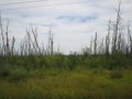
There was no road here,
so I started here,
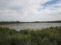
then went around the pond,
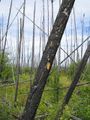
and through the fireswamps
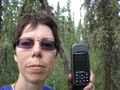
to destination. I look terrible
but I survived the raptor attack.


Things I Learned Today
- Terrain and vegetation can change abruptly, multiple times, within a kilometre or two.
- There is a never ending variety of ways in which terrain can be difficult to traverse.
- Slave Lake vegetation can make roads disappear.
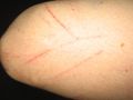
- Human skin is tougher than you might think. Mine took a lot of abuse but most of it is still attached.
- What other learned from your trip
- When you burn onifers, you get harcoal. :D -- Relet 10:07, 25 August 2008 (UTC)