Difference between revisions of "2019-09-16 52 9"
From Geohashing
(new report) |
(expedition report for Hildesheim) |
||
| Line 1: | Line 1: | ||
| − | + | {{meetup graticule | |
| − | |||
| − | |||
| − | |||
| − | |||
| − | |||
| − | |||
| − | |||
| − | |||
| lat=52 | | lat=52 | ||
| lon=9 | | lon=9 | ||
| date=2019-09-16 | | date=2019-09-16 | ||
| − | }} | + | }} |
| + | |||
__NOTOC__ | __NOTOC__ | ||
== Location == | == Location == | ||
| − | + | ||
| + | The hash lay on the southern ramp of a footbridge between Lerchenkamp and Pestalozzistraße in Hildesheim. | ||
== Participants == | == Participants == | ||
| − | + | ||
| − | + | [[User:GeorgDerReisende|GeorgDerReisende]] | |
== Plans == | == Plans == | ||
| − | + | ||
| + | Traveling by public transport to Hildesheim and walking to the hash. | ||
== Expedition == | == Expedition == | ||
| − | + | ||
| + | All as planned. I arrived at the former airbase of Hildesheim and walked to the hash and found it on the way. | ||
== Tracklog == | == Tracklog == | ||
| − | + | ||
| + | During the [[Dark Ages]] I logged all expeditions by contributing to [https://commons.wikimedia.org/wiki/User:GeorgDerReisende/geohashing Wikimedia Commons]. View all photos of this expedition [https://commons.wikimedia.org/wiki/Category:Files_by_User:GeorgDerReisende/20190916 here]. | ||
== Photos == | == Photos == | ||
| − | < | + | |
| − | + | <gallery> | |
| − | -- | + | File:2019-09-16 52 9 GeorgDerReisende 0420.jpg | the street Lerchenkamp in the north |
| − | + | File:2019-09-16 52 9 GeorgDerReisende 0419.jpg | entrance to the footway | |
| + | File:2019-09-16 52 9 GeorgDerReisende 0423.jpg | coming from the north | ||
| + | File:2019-09-16 52 9 GeorgDerReisende 0425.jpg | the bypass of Hildesheim | ||
| + | File:2019-09-16 52 9 GeorgDerReisende 0427.jpg | view to the hash from the north | ||
| + | File:2019-09-16 52 9 GeorgDerReisende 0429.jpg | the hash on the way | ||
| + | File:2019-09-16 52 9 GeorgDerReisende 0430.jpg | looking east | ||
| + | File:2019-09-16 52 9 GeorgDerReisende 0431.jpg | looking west | ||
| + | File:2019-09-16 52 9 GeorgDerReisende 0432.jpg | looking north | ||
| + | File:2019-09-16 52 9 GeorgDerReisende 0433.jpg | the geohasher | ||
| + | File:2019-09-16 52 9 GeorgDerReisende 0434.jpg | view to the hash from the south | ||
| + | File:2019-09-16 52 9 GeorgDerReisende 0435.jpg | the Pestalozzistraße in the south | ||
</gallery> | </gallery> | ||
| Line 40: | Line 47: | ||
<!-- Add any achievement ribbons you earned below, or remove this section --> | <!-- Add any achievement ribbons you earned below, or remove this section --> | ||
| − | + | {{Dark Ages | latitude = 52 | longitude = 9 | date = 2019-09-16 | name = GeorgDerReisende }} | |
| − | |||
| − | |||
| − | + | [[Category:Expeditions]] | |
| − | + | [[Category:Expeditions with photos]] | |
| − | |||
| − | [[Category: | ||
| − | |||
| − | + | [[Category:Expedition without GPS]] | |
| − | |||
| − | |||
| − | |||
| − | |||
| − | |||
| − | |||
| − | |||
| − | |||
| − | |||
[[Category:Coordinates reached]] | [[Category:Coordinates reached]] | ||
| − | |||
| − | |||
| − | |||
| − | |||
| − | |||
| − | |||
| − | |||
| − | |||
| − | |||
| − | |||
| − | |||
| − | |||
| − | |||
| − | |||
| − | |||
| − | |||
| − | |||
| − | |||
Revision as of 10:01, 4 April 2020
| Mon 16 Sep 2019 in 52,9: 52.1703533, 9.9454150 geohashing.info google osm bing/os kml crox |
Location
The hash lay on the southern ramp of a footbridge between Lerchenkamp and Pestalozzistraße in Hildesheim.
Participants
Plans
Traveling by public transport to Hildesheim and walking to the hash.
Expedition
All as planned. I arrived at the former airbase of Hildesheim and walked to the hash and found it on the way.
Tracklog
During the Dark Ages I logged all expeditions by contributing to Wikimedia Commons. View all photos of this expedition here.
Photos

the street Lerchenkamp in the north
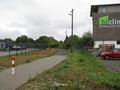
entrance to the footway

coming from the north
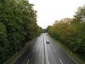
the bypass of Hildesheim

view to the hash from the north
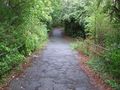
the hash on the way
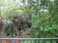
looking east

looking west

looking north
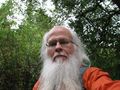
the geohasher

view to the hash from the south

the Pestalozzistraße in the south


Achievements
GeorgDerReisende earned the Dark Ages achievement
|