Difference between revisions of "2019-09-26 51 8"
(new report) |
(expedition report for Lippstadt-Mettinghausen) |
||
| Line 1: | Line 1: | ||
| − | + | {{meetup graticule | |
| − | |||
| − | |||
| − | |||
| − | |||
| − | |||
| − | |||
| − | |||
| − | |||
| lat=51 | | lat=51 | ||
| lon=8 | | lon=8 | ||
| date=2019-09-26 | | date=2019-09-26 | ||
| − | }} | + | }} |
| + | |||
__NOTOC__ | __NOTOC__ | ||
== Location == | == Location == | ||
| − | + | ||
| + | The hash lay at some trees north of Mettinghausen. | ||
== Participants == | == Participants == | ||
| − | + | ||
| − | + | [[User:GeorgDerReisende|GeorgDerReisende]] | |
== Plans == | == Plans == | ||
| − | + | ||
| + | Traveling by public transport to Mettinghausen and a walk. | ||
== Expedition == | == Expedition == | ||
| − | + | ||
| + | This day I had some problems with the journey. To travel from Kassel to Lippstadt, where Mettinghausen belongs to, needs to take the train from Kassel to Warburg and change there to the train from Warburg to Lippstadt (and further). On this day the train from Warburg on was cancelled due to the lack of train drivers and there was a SEV scheduled (SEV = Schienenersatzverkehr = railway replacement service). But my experience with such SEV-services is, that they are seldom, late and other public transport services don't wait for them. Not even trains or buses of the same operator. Seeing the announcement und with the experience I decided quickly to travel on with the first train to Meschede and to try the bus service from there to Lippstadt. I needed to change the bus at Warstein (don't confuse Warstein with Warburg) and reached Lippstadt in time to get the bus to Mettinghausen (this runs only twice a day on schooldays). So I arrived at Mettinghausen without delay. | ||
| + | |||
| + | At Mettinghausen I walked to the hash. I found it under some trees at the edge of a field. But across the way along this edge there was a fence with a private property sign. But the field was empty. And it was possible to walk from the street onto the field and then from the field onto the fieldway behind the fence. Other people had done this before with their cars. | ||
== Tracklog == | == Tracklog == | ||
| − | + | ||
| + | During the [[Dark Ages]] I logged all expeditions by contributing to [https://commons.wikimedia.org/wiki/User:GeorgDerReisende/geohashing Wikimedia Commons]. View all photos of this expedition [https://commons.wikimedia.org/wiki/Category:Files_by_User:GeorgDerReisende/20190926 here]. | ||
== Photos == | == Photos == | ||
| − | < | + | |
| − | + | <gallery> | |
| − | -- | + | File:2019-09-26 51 8 GeorgDerReisende 1561.jpg | arrived at Mettinghausen |
| − | + | File:2019-09-26 51 8 GeorgDerReisende 1575.jpg | hash bulls | |
| + | File:2019-09-26 51 8 GeorgDerReisende 1578.jpg | on a field with a fence around they're looking cuddly, but in a pedestrian area in the city they have a different feeling | ||
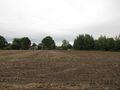
| + | File:2019-09-26 51 8 GeorgDerReisende 1586.jpg | hash area | ||
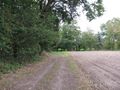
| + | File:2019-09-26 51 8 GeorgDerReisende 1587.jpg | the fieldway to the hash with a fence blocking it | ||
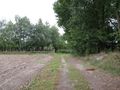
| + | File:2019-09-26 51 8 GeorgDerReisende 1589.jpg | the way around | ||
| + | File:2019-09-26 51 8 GeorgDerReisende 1590.jpg | this is the hash tree | ||
| + | File:2019-09-26 51 8 GeorgDerReisende 1591.jpg | standing in front of the tree | ||
| + | File:2019-09-26 51 8 GeorgDerReisende 1592.jpg | looking south | ||
| + | File:2019-09-26 51 8 GeorgDerReisende 1593.jpg | looking west | ||
| + | File:2019-09-26 51 8 GeorgDerReisende 1594.jpg | looking east | ||
| + | File:2019-09-26 51 8 GeorgDerReisende 1595.jpg | the geohasher | ||
</gallery> | </gallery> | ||
| Line 40: | Line 49: | ||
<!-- Add any achievement ribbons you earned below, or remove this section --> | <!-- Add any achievement ribbons you earned below, or remove this section --> | ||
| − | + | {{Dark Ages | latitude = 51 | longitude = 8 | date = 2019-09-26 | name = GeorgDerReisende }} | |
| − | |||
| − | |||
| − | + | [[Category:Expeditions]] | |
| − | + | [[Category:Expeditions with photos]] | |
| − | |||
| − | [[Category: | ||
| − | |||
| − | + | [[Category:Expedition without GPS]] | |
| − | |||
| − | |||
| − | |||
| − | |||
| − | |||
| − | |||
| − | |||
| − | |||
| − | |||
[[Category:Coordinates reached]] | [[Category:Coordinates reached]] | ||
| − | |||
| − | |||
| − | |||
| − | |||
| − | |||
| − | |||
| − | |||
| − | |||
| − | |||
| − | |||
| − | |||
| − | |||
| − | |||
| − | |||
| − | |||
| − | |||
| − | |||
| − | |||
Revision as of 18:51, 7 April 2020
| Thu 26 Sep 2019 in 51,8: 51.7104899, 8.4255585 geohashing.info google osm bing/os kml crox |
Location
The hash lay at some trees north of Mettinghausen.
Participants
Plans
Traveling by public transport to Mettinghausen and a walk.
Expedition
This day I had some problems with the journey. To travel from Kassel to Lippstadt, where Mettinghausen belongs to, needs to take the train from Kassel to Warburg and change there to the train from Warburg to Lippstadt (and further). On this day the train from Warburg on was cancelled due to the lack of train drivers and there was a SEV scheduled (SEV = Schienenersatzverkehr = railway replacement service). But my experience with such SEV-services is, that they are seldom, late and other public transport services don't wait for them. Not even trains or buses of the same operator. Seeing the announcement und with the experience I decided quickly to travel on with the first train to Meschede and to try the bus service from there to Lippstadt. I needed to change the bus at Warstein (don't confuse Warstein with Warburg) and reached Lippstadt in time to get the bus to Mettinghausen (this runs only twice a day on schooldays). So I arrived at Mettinghausen without delay.
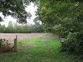
At Mettinghausen I walked to the hash. I found it under some trees at the edge of a field. But across the way along this edge there was a fence with a private property sign. But the field was empty. And it was possible to walk from the street onto the field and then from the field onto the fieldway behind the fence. Other people had done this before with their cars.
Tracklog
During the Dark Ages I logged all expeditions by contributing to Wikimedia Commons. View all photos of this expedition here.
Photos
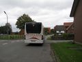
arrived at Mettinghausen
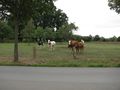
hash bulls
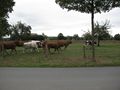
on a field with a fence around they're looking cuddly, but in a pedestrian area in the city they have a different feeling
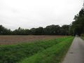
hash area
the fieldway to the hash with a fence blocking it
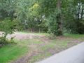
the way around
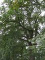
this is the hash tree
standing in front of the tree
looking south
looking west
looking east
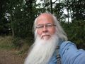
the geohasher


Achievements
GeorgDerReisende earned the Dark Ages achievement
|