Difference between revisions of "2020-05-13 51 7"
From Geohashing
(Created page with "{{meetup graticule | lat=51 | lon=7 | date=2020-05-13 }} __NOTOC__ == Location == On the edge of a field south of Münster (between Rinkerode and Albersloh), Northrhine-We...") |
m (Location) |
||
| Line 45: | Line 45: | ||
[[Category:Expeditions with photos]] | [[Category:Expeditions with photos]] | ||
[[Category:Coordinates reached]] | [[Category:Coordinates reached]] | ||
| + | {{location|DE|NW|WAF}} | ||
Revision as of 15:42, 13 May 2020
| Wed 13 May 2020 in 51,7: 51.8596598, 7.7050245 geohashing.info google osm bing/os kml crox |
Location
On the edge of a field south of Münster (between Rinkerode and Albersloh), Northrhine-Westphalia, Germany.
Participants
Expedition
I had to be back at noon for (online) university lectures, but with the hash being only ~1h of cycling away, I set off at about 9:30am. I took the fast and ugly way to the hash following a main road. Luckily the hash was located at the border between to fields meaning I didn't have to walk across the freshly sown field.
On the way back I took the nicer path through the forest and water protection area "Hohe Ward" where I found a nice building which is apparently part of the water works.
Photos
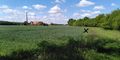
The hash.
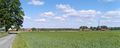
Just a nice view close to the hash. Good sky.
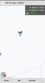
Proof.
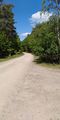
The nicer path.
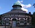
The waterworks in Hohe Ward.


Achievements
BroFi earned the Bicycle geohash achievement
|